GIM International Launches Second UAS Special
After a very successful first edition, GIM International now has published a second issue dedicated to UAS, bringing you details of the very latest developments in the sector. The magazine...

After a very successful first edition, GIM International now has published a second issue dedicated to UAS, bringing you details of the very latest developments in the sector. The magazine...

The Schiebel camcopter S-100 UAS (in co-operation with JSC Gorizont Russia: Gorizont Air S-100) was in operation in Sochi during the XXII Winter Olympics and will continue to operate during...
With today’s operational unmanned aerial systems (UAS), photogrammetry has entered a new era. However, not every unmanned aerial vehicle (UAV) is suited for aerial mapping. The ability to fly at...
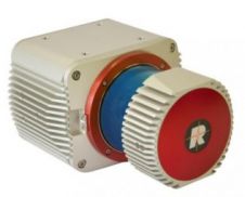
RIEGL Laser Measurement Systems has been developing their first survey-grade UAS Lidar sensor, the VUX-1, and the company will be presenting it later this month. The VUX-1 will be presented...

In view of the rapid emergence of UAS in the geomatics sector, and after a very successful first edition, GIM International is due to publish a second UAS special, bringing...

After a very successful and well-received first edition, GIM International is now planning to publish a second UAS special, bringing you details of the very latest developments relating to UAS....

The Aibot X6, developed by Aibotix in Kassel, Germany, and designed to carry out inspections or operations too dangerous for humans to carry out, can reach places that conventional devices...

UAS from senseFly, Switzerland, have accomplished their second mission in Haiti to map areas around Port-au-Prince and Cap Haitien, including areas that were damaged by Hurricane Sandy in October 2012....
For the first time in the history of the famous Cathedral of Canterbury, England, permission was given to operate a remote flying camera inside and through the Cathedral. The EagleCam...

In recognition of the growing importance of UAS in the geomatics sector, GIM International has been publishing a series of articles on the use of UAS in geomatics over the...
This site uses cookies. By continuing to use this website, you agree to our Cookies Policy. Agree