Joint Mapping of the Barents Sea
Norway and Russia will this month begin a joint mapping of undiscovered natural resources in the Barents Sea and around the Norwegian Arctic archipelago of Svalbard. The Norwegian Petroleum Directorate...
Norway and Russia will this month begin a joint mapping of undiscovered natural resources in the Barents Sea and around the Norwegian Arctic archipelago of Svalbard. The Norwegian Petroleum Directorate...
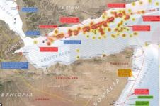
The Gulf of Aden is currently one of the world's most dangerous shipping routes. Pirates originating from Somalia, or rather that part of the country called Puntland, launch frequent attacks...
Veripos, a world leader in the provision of precise Global Navigation Satellite System positioning solutions to the offshore oil and gas industry, has been commissioned by ARIS Geophysical of Moscow...

Greater tracking reliability and enhanced decision-making data are available for the Fanbeam laser-based marine positioning system with the launch of new control software from Measurement Devices Ltd (MDL), a leading...
Final permission has been granted to Nord Stream AG to start construction of a natural-gas pipeline through the Baltic Sea. All permits required by the four countries through whose territorial...

iXSea's strength is in technology. Of its roughly 200 employees, a third are engaged in R&D. The company holds 21 key patents in the area of navigation and positioning -...

Hi-tech 3D modelling software from Pointools is being employed by University College of London (UCL) to create 3D computer visualisations of environmental installations. Researchers at the acclaimed Bartlett School of...
Fugro expects to realise a revenue of more than EUR2.2 billion over the full year 2010 (2009: EUR 2.05 billion). Baring unforeseen circumstances, the net result after tax is expected...
At INTERGEO 2010, Applanix has announced a new version of its post-processing software for Mobile Mapping and Positioning, POSPac MMS version 5.4. Designed to enhance the productivity of Mobile Mapping,...
An innovative, integrated `plug-and-play' mobile mapping system, which can be used on land or at sea, is being showcased at Intergeo, Cologne October 5th - 7th 2010. Laser scanning, GPS...
This site uses cookies. By continuing to use this website, you agree to our Cookies Policy. Agree