Invitation to Participate in XXIV ISPRS Congress 2021
In view of the ongoing pandemic situation, ISPRS is organizing an extended digital edition of the XXIV Congress from 5-9 July this year, with all the features of an ISPRS...

In view of the ongoing pandemic situation, ISPRS is organizing an extended digital edition of the XXIV Congress from 5-9 July this year, with all the features of an ISPRS...

GeoFly has taken delivery of its new DA62 SurveyStar aerial survey aircraft and the Special Mission Aircraft is now ready for deployment from GeoFly's base at Magdeburg Business Airport, Germany....
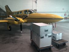
Hansa Luftbild has purchased a new UltraCam Eagle Mark 3 system to continue to meet customer requirements. “The UltraCam Eagle Mark 3 is our flagship and the perfected version of...

This webinar gives you insights into our recently introduced UltraCam Osprey 4.1, its system architecture, key features, data processing and visualization. Alexander Wiechert, CEO of Vexcel Imaging, and Bernhard Schachinger,...

Vexcel Imaging has released UltraMap version 5.0, the latest update of its all-in-one aerial photogrammetry software featuring comprehensive DTM generation and full integration of orthophoto production in UltraMap Studio. With the introduction of a completely new Digital Terrain Model...

Vexcel Imaging has announced the release of the next-generation UltraCam Osprey 4.1, which is described as a highly versatile large-format aerial camera for the simultaneous collection of photogrammetric-grade nadir imagery...

Members of the European Association of Aerial Surveying Industries (EAASI) came together for a virtual meeting to question two of the industry’s leading sensor manufacturers about their recent acquisitions of...

Vexcel Imaging, a company specialized in aerial imagery data, large-format aerial cameras and photogrammetry software, has signed a definitive agreement to acquire the imagery sourcing group from Verisk’s Geomni business....
With just two months to go until the first-ever edition of Geo Connect Asia 2020, organizers Montgomery Asia have announced the first wave of speakers and exhibitors. This March, the...

Delegates from around the world flocked to the first European Association of Aerial Surveying Industries (EAASI) Summit. Attracted by a topical conference programme, working group sessions and a variety of...
This site uses cookies. By continuing to use this website, you agree to our Cookies Policy. Agree