For Digital Twins, Openness Wins
What would you say if you could wave a magic wand and eliminate all the time and effort that you and your organization spend on transforming data, integrating data and...
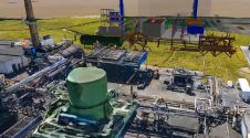
What would you say if you could wave a magic wand and eliminate all the time and effort that you and your organization spend on transforming data, integrating data and...

International aquatic remote sensing company EOMAP recently showcased its unique contribution to the world's first 3D habitat map of the Great Barrier Reef (GBR) at the International Forum on Satellite-Derived...
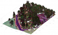
The arrival of airborne Lidar, also referred to as airborne laser scanning (ALS), has revolutionized area-wide 3D data acquisition of topography, bathymetry, vegetation, buildings and infrastructure. This article presents an...
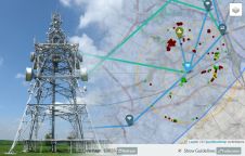
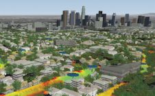
3D digital models derived from high-resolution aerial photography are helping network operators plan the rollout of services including WISP (Fixed Wireless Access), 5G and Smart City applications. The work by...
Which technologies and processes are building the capability for high-density 3D data? Point clouds can be captured by an ever-increasing number of means to understand the surrounding reality and detect critical...

HERE Technologies, Shields and Infosys have announced that they are collaborating on a powerful and cost-effective way to perform 5G network design and deployment. The new solution, to be demonstrated...
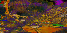
LuxCarta, a provider of geodata to the wireless ecosystem, has announced it is providing specialized geodata designed for use with RF planning simulations at high frequencies to Telefónica Deutschland and...

There is an abundance of data today, but how can it be processed, visualised and analysed to deliver real business benefits? We are in the midst of a digital transformation,...

Today’s digital societies require a continuous supply of updated, reliable and correct geodata, and new technologies are arriving with increasing speed. The manned aerial survey is by far the main...

By the time you read this, we will be into the 2018/19 evening lecture sessions. These evening events are a real fulcrum of interaction, geospatial market insight, outreach and a...
This site uses cookies. By continuing to use this website, you agree to our Cookies Policy. Agree