Web GIS Improves Lidar Collection Response Time
The remarkable capabilities of airborne Lidar continue to improve, with scanners now able to emit more than a million pulses every second. Although it has never been easier to acquire...
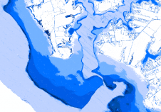
The remarkable capabilities of airborne Lidar continue to improve, with scanners now able to emit more than a million pulses every second. Although it has never been easier to acquire...

Whenever anyone talks about Lidar technology in the geospatial sector, it is only a matter of time before the name RIEGL is mentioned. Thanks to its renowned R&D department, the...
How can photogrammetric equipment and software developers provide the mapping and surveying community with solutions that are sophisticated, yet also meet high customer expectations in terms of user-friendliness? Photogrammetry is...

HxGN SmartNet, the world’s largest precise positioning service with more than 4,500 reference stations worldwide, has arrived in Mexico City and surrounding areas. HxGN SmartNet is a GNSS correction service...

James Kavanagh has given a report on the FIG Congress with particular reference to UK interests. Here we look at some of the wider issues from the technical sessions. Surveying...
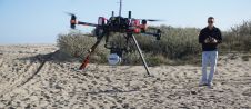
YellowScan, a designer, developer and producer of UAV-Lidar solutions for professional applications, continues to expand its presence in the USA with the opening of a new office located in Salt...

The beautiful city of Istanbul in Turkey played host to the XXVI International Federation of Surveyors (FIG) Congress from 6-11 May 2018. With the theme of ‘Embracing Our Smart World Where...

London’s docklands became home to a fleet of both manned and unmanned surface and subsea vehicles during this year’s Oceanology International 2018 (Oi18), reflecting an increasing focus on connected autonomous...

Over the last five years we have seen a clear move by technology manufacturers away from a ‘horizontal’ approach providing sensors and data capture systems for as many different customers...

Based on a future-oriented, innovative new processing architecture, internet connectivity and RIEGL‘s latest waveform processing Lidar technology, the RIEGL VZ-2000i Long Range 3D Laser Scanner System combines proven user friendliness in the field...
This site uses cookies. By continuing to use this website, you agree to our Cookies Policy. Agree