Networks and Democracy
Digital heritage is a fast-moving field, with the nature of the technologies themselves dictating the culture of their usage and the type of people that can use them. These technologies...

Digital heritage is a fast-moving field, with the nature of the technologies themselves dictating the culture of their usage and the type of people that can use them. These technologies...
Cyprus University of Technology has selected ERDAS APOLLO to manage and deliver its vector and raster data for several National Offices in Cyprus. GEOINFORMATION S.A., the distributor of ERDAS in...

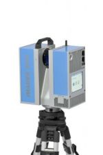
Leica Geosystems announces three new laser scanning software products for scan data import, forensic scene mapping and modelling complex 3D surfaces. These products – Cyclone Importer, ForensicMap Pro and 3DReshaper...

Rapid developments in GIS technology and its applications, and thus growing demand for geospatial data, encouraged a group of friends including geodesists, IT people and foresters to create an innovative,...
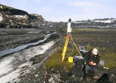
The latest laser scanning and remote controlled aircraft technology are to be used to monitor glaciers where unstable slopes and rock falls are a continual threat. A Riegl LMS-Z620 long-range...
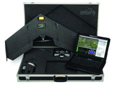
KOREC, UK, is to become the sole UK and Irish distributor of SenseFLY’s unmanned flying camera, the swinglet CAM made by the Swiss company, SenseFLY. The swinglet CAM is a...

Leica Geosystems Germany has launched its own GNSS Network RTK service. SmartNet Germany is based on a close partnership between SAPOS, the service of Surveying Authorities of the Federal Republic...
Based in Germany with subsidiaries in the UK and the US, Zoller + Fröhlich is represented worldwide through a global network of local partners in 40 different nations. Founded in...

Nottingham’s architectural heritage is enjoying a new lease of life thanks to a University project to survey almost 450 caves located below the UK City. The survey project is being...

In August 2011, ISPRS signed a contract with MDPI AG of Basel, Switzerland, to establish the open access ISPRS International Journal of Geo-Information [website 1]. This is the first ISPRS-owned...
This site uses cookies. By continuing to use this website, you agree to our Cookies Policy. Agree