Telcontar Name Change to deCarta
Telcontar (CA, USA) is changing its corporate name to deCarta. The new corporate identity reflects the company's objective and commitment to deliver the most advanced geospatial software and services to...
Telcontar (CA, USA) is changing its corporate name to deCarta. The new corporate identity reflects the company's objective and commitment to deliver the most advanced geospatial software and services to...
CARIS (Canada) appointed a new vice president of CARIS USA. Paul R. Cooper has joined the CARIS executive team and will be responsible for directing all aspects of the company's...
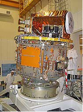
Thailand's first geography-surveying satellite ''Theos'' is expected to be launched into orbit October 2007. The six-billion-baht satellite, officially called Thailand Earth Observation System (Theos), is being built by France-based Astrium...
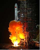
China has successfully put a navigation satellite into orbit on 3rd February from the Xichang Satellite Launch Centre in southwest China's Sichuan Province. The carrier rocket, Long March 3-A, blasted...
In 2007, the fourth Intergeo East conference is to be held outside the former Yugoslavian region for the first time. The trade fair and conference for land management, geoinformation, the...
The structure of international scientific societies such as ICA and the other geomatics organisations profiled in GIM International is primarily built on the idea of national representation. It is not...
With a history stretching back to 1831, the National Mapping Agency (NMA) of Belgium has always respected the scientific approach. In 2006 it underwent a complete restructuring of work processes...
Preliminary program of the 3rd International Conference “Earth From Space – The Most Effective Solutions” has been made public. The conference, organised by RDC ScanEx and NGO Transparent World, is...
The Geo-Siberia 2007 conference and exhibition was held in Novosibirsk, Russian Federation from 25th to 27th April 2007. Organised by the Siberian State Academy of Geodesy (SSGA) in Novosibirsk, it...
The ICA Commission on Mountain Cartography was established in 1999 to define the topics involved and promote methods and knowledge of mountain cartography among scientists and professionals in cartography and...
This site uses cookies. By continuing to use this website, you agree to our Cookies Policy. Agree