Czech Technical University, Faclt. Civil Engineering

As part of its continued expansion into Africa, Getmapping has taken over Promap Civil Engineering Surveys, based in Pretoria. Promap is a leading supplier of aerial and ground survey services...
Carlson Software (KY, USA) has formally formed a Civil Engineering Division incorporating its civil software development team and a specialised sales force headquartered in strategic locations throughout the U.S. and...

3D visualization is at the heart of many geospatial data applications. Progress in 3D visualization has drastically reduced barriers to entry for new products based on large datasets, thanks to...
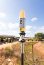
Topcon Positioning Systems has presented the latest addition to its HiPer family of global navigation satellite system (GNSS) receivers. The HiPer CR is a compact and lightweight GNSS receiver designed...
YellowScan has announced the global launch of its new Lidar UAS surveying solution with highest accuracy and most dense georeferenced point cloud data. Weighing only 1.5kg, the YellowScan Surveyor has...

Sven Cowan is NV5 Geospatial’s Programme Manager for Canada. He has over 20 years of experience in customer-facing positions within the geospatial information industry and has worked for multiple geospatial...

Visitor registration is now open for GEO Business, the UK's largest geospatial event. The free-to-attend expo, tailored for geospatial professionals seeking to harness the potential of location intelligence, will return...

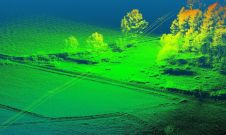
A topobathymetric Lidar survey was conducted to support flood preparedness in Canada. Which techniques achieved exceptional precision, and what were the logistical challenges? Find out more in this article. As...
This site uses cookies. By continuing to use this website, you agree to our Cookies Policy. Agree