Laser-scanning and Heritage
The March issue of GIM International carried the response of manufacturers of laser-scanning sensors and software to remarks made in the Insider’s View column on shortcomings of this technology in...
The March issue of GIM International carried the response of manufacturers of laser-scanning sensors and software to remarks made in the Insider’s View column on shortcomings of this technology in...
QCoherent Software (Co, USA) has released LP360 version 1.3, a Lidar extension for ArcGIS. LP360 employs a specially designed ArcMap data layer to access and draw LIDAR points directly from...
Visual Learning Systems Inc. (VLS) has released Lidar Analyst 4.1, which is now available to automatically extract features and more. Lidar Analyst completely automates the collection of attributed 3-D buildings,...
kubit GmbH (Germany) has establishment an USA office in Houston, Texas. Besides TachyCAD, surveying tool for directly inputting existing conditions into CAD systems, kubit develops PhoToPlan for rectifying photographic images...
Terrestrial 3D laser scanning will become the future standard tool for high-resolution 3D documentation of archaeological excavations, but its capabilities are still underestimated by professional archaeologists and providers of scanners...
Leica Geosystems (Switzerland) announces Leica CloudWorx 1.0 for PDMS. CloudWorx 1.0 for PDMS is the latest addition to the Leica CloudWorx suite of products that enable professionals to use rich,...
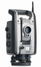
Trimble (CA, USA) has introduced new and enhanced surveying products as part of its Connected Site model: the new Trimble S8 Total Station and Trimble 4D Control Software for engineering...
In GIM International December 2004 we published an earlier product survey on 3D terrestrial laser scanners. The successful use of laser-scanner systems depends not only on the characteristics of the...
ComputaMaps (South Africa) has released BrightEarth, a natural colour image mosaic covering 95% of the Earth’s land surface at a resolution of 14.25m. The source of BrightEarth is the orthorectified...
The Ecosystems Atlas of South America and Antarctica is an educational programme for primary-school pupils. Software is distributed free to South American institutions that develop educational activities relating to the...
This site uses cookies. By continuing to use this website, you agree to our Cookies Policy. Agree