Accurate footprints from Antarctica
Remote sensing surveys in Antarctica based on unmanned aerial vehicles (UAVs or ‘drones’) have become a very important approach for a wide range of studies. Mapping free-from-ice-and-snow terrain and monitoring...
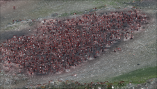
Remote sensing surveys in Antarctica based on unmanned aerial vehicles (UAVs or ‘drones’) have become a very important approach for a wide range of studies. Mapping free-from-ice-and-snow terrain and monitoring...
SkyWatch has been selected by the Canadian Space Agency (CSA) to complete Phase 2 of the Artificial Intelligence and Big Data Analytics for Advanced Autonomous Space Systems challenge. This award...
A team from Greece studied the use of aerial imagery to achieve wide coverage of a predefined geometrical area of interest in a project to explore the contribution of UAVs...

The third edition of Geo Connect Asia (GCA), Southeast Asia's premier geospatial and location intelligence technology trade event, drew to a close on 16 March 2023, at the Marina Bay...
The use of AI in monitoring and modelling climate conditions is bringing about a revolution, especially in the field of geospatial data collection and mapping. With the help of AI-powered...

At OxTS, in line with our brand promise of being inertial navigation experts, our commitment to our customers is that we will keep innovating until we can help them truly ‘navigate anywhere’ – with or without GNSS. We are advancing our products in that direction by first enhancing urban navigation data quality based on sensor fusion. Here, we explain how. At OxTS, in line with our brand promise of being inertial navigation experts, our commitment to our customers is that we will keep innovating until we can help them truly...

The countdown is on for GEO Business 2023, a top trade event that brings together experts and professionals in the geospatial field. Co-located with the Digital Construction Week, the event...

Geospatial and built environment professionals recently gathered for Geo Week, held from 13-15 February at the Colorado Convention Center in Denver. USA. Geo Week is one of the leading conferences...
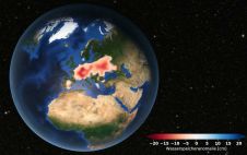
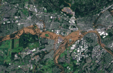
Europe is suffering from a severe drought. Satellite data analysed at TU Graz's Institute of Geodesy confirms that groundwater levels have been consistently low since 2018. Although extreme weather events...

During the Open Data Challenge hackathon held in Tashkent, the capital of Uzbekistan, more than 200 students, divided into 50 teams, spent three days using geodata to tackle the country's...
This site uses cookies. By continuing to use this website, you agree to our Cookies Policy. Agree