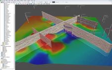
Found 56 results
Sort by

Multi-sensor Coastal Mapping

Fugro has tested a multi-sensor approach to balance growing data needs with limited agency budgets. Coastal mapping programmes are quickly becoming a priority for government agencies across the globe. The desire...

Read more

The African Geodetic Reference Frame

The African Geodetic Reference Frame (AFREF) was conceived to unify the patchwork of geodetic reference frames and vertical datums in the 54 countries in Africa. A common reference frame is...

Read more

Famous Czech Scientists

ISPRS Congress assembles every four years at some attractive location in the world, to welcome participants from all over the globe who meet to discover, report and exchange ideas on...

Read more

Mapping Nocturnal Light Pollution

Artificial light in urban conglomerates causes nocturnal light pollution. Excessive light radiation is expensive as it wastes energy and not only impacts the environment but may also harm human health....

Read more

CGG Launches Major GeoSoftware Releases

CGG, France, has announced that its GeoSoftware business line is launching major releases across its full product portfolio. Focused on technology innovation, workflow integration and ease of use across all...

Read more