New UN organization to highlight the value of geodesy
The brand-new United Nations Global Geodetic Centre of Excellence (UN-GGCE) is now operational at the United Nations campus in Bonn, Germany. Nicholas Brown, head of office of the UN-GGCE, is...

The brand-new United Nations Global Geodetic Centre of Excellence (UN-GGCE) is now operational at the United Nations campus in Bonn, Germany. Nicholas Brown, head of office of the UN-GGCE, is...

The Australian government has committed to participating in Landsat Next, a groundbreaking satellite initiative spearheaded by NASA and the US Geological Survey. This programme aims to comprehensively map and monitor...

In the ever-evolving landscape of climate change, geospatial science emerges as a key player in navigating the complexities of our transforming world. The European Association of Aerial Surveying Industries (EAASI)...

The fourth edition of Geo Connect Asia (GCA), celebrated as the region's premier trade event and conference for the geospatial, positioning and remote sensing industries, truly delivered during its two-day...

SimActive has reported that the use of its Correlator3D product along with ground control points can enhance, extend and validate photogrammetry projects. GCPs are critical in photogrammetry projects, but there...

Despite some uncertainty, there is renewed interest in drones, and remote sensing technologies are being embraced by smaller survey companies. Read these and other findings from our annual industry survey!...
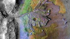
Using ground-penetrating radar, NASA’s Perseverance rover has uncovered compelling evidence of ancient lake sediment on Mars. This confirms the longstanding hypothesis that the Red Planet was once a warm, wet...
In this article, Craig Simmonds presents massive advances in ground-probing radar and discusses the journey of the technology over the past quarter of a century. He particularly highlights the major...
Airbus has launched its new series of radar-derived Ground Control Points (GCPs), offering high point density and centimetre-level accuracy. Users can extract accurate 3D coordinates from high-resolution stereo radar imagery...
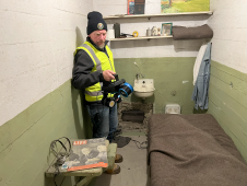
The rugged 22.5-acre site of the notorious US island prison Alcatraz has been digitally captured in a world-leading project involving multiple mapping technologies. With the team camped in the jail’s infamous cells for three weeks during the cold San Francisco winter, this historically, biologically and architecturally important location was recorded in unprecedented 3D detail. We discussed the project with project head Pete Kelsey and team member Dr Jeremy Sofonia. The rugged 22.5-acre site of the notorious US island prison Alcatraz has been digitally captured in a world-leading project involving multiple mapping technologies. With the team camped in the jail’s infamous cells...
This site uses cookies. By continuing to use this website, you agree to our Cookies Policy. Agree