Real-time Deformation Monitoring
Trimble has introduced today two new features for its Trimble 4D Control software solution for monitoring systems. The features include support for geotechnical sensors and a user-friendly Web Module. The...
Trimble has introduced today two new features for its Trimble 4D Control software solution for monitoring systems. The features include support for geotechnical sensors and a user-friendly Web Module. The...
Snowflake Software has finished a pilot project the UK Met Office. The pilot project was a response to the needs of the UK's highway authorities to respond to continuously changing...

Leica Geosystems has added a software module to its GeoMoS Monitoring Software. Leica GeoMoS HiSpeed is a professional software tool for deformation analysis of high-frequency data. Together with a high-precision...
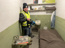
The rugged 22.5-acre site of the notorious US island prison Alcatraz has been digitally captured in a world-leading project involving multiple mapping technologies. With the team camped in the jail’s infamous cells for three weeks during the cold San Francisco winter, this historically, biologically and architecturally important location was recorded in unprecedented 3D detail. We discussed the project with project head Pete Kelsey and team member Dr Jeremy Sofonia. The rugged 22.5-acre site of the notorious US island prison Alcatraz has been digitally captured in a world-leading project involving multiple mapping technologies. With the team camped in the jail’s infamous cells...
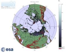
Satellite information on snow cover is now available through ESA's GlobSnow project soon after it snows. As well as posing a hazard to communities through transportation shutdowns and floods, snow...
3D TARGET was founded as a trading company and official distributor of non-destructive measuring instruments. In 2016, we created an internal R&D division dedicated to system integration and designed a...
In September-November ScanEx has performed tests with real-time water oil spills detection technique using RADARSAT-1 space images, along the northern coastline of the Caspian Sea. The data reception and processing...
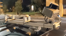
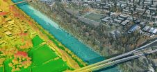
Klau Geomatics has introduced the Brumby RTK Lidar system, an innovative mobile mapping solution equipped with powerful Edge Compute capabilities, enabling the generation of highly precise georeferenced point clouds in...

3D visualization is at the heart of many geospatial data applications. Progress in 3D visualization has drastically reduced barriers to entry for new products based on large datasets, thanks to...
Leica Geosystems, part of Hexagon, has launched the Leica TerrainMapper-3 airborne Lidar sensor, featuring new scan pattern configurability to support the widest variety of applications and requirements in a single...
This site uses cookies. By continuing to use this website, you agree to our Cookies Policy. Agree