CHC Navigation is expanding its reach throughout Europe and the world, with more dealers and customer support and advanced training and service points. The Shanghai-based company has been a player in the mobile mapping industry for almost two decades. Founded in 2003, initially as a provider of GNSS technologies for the domestic market in China, the company’s evolution has since tracked the stellar expansion of the GNSS navigation and positioning industry.
CHCNAV now offers end-to-end precision positioning solutions encompassing both hardware and software for applications in land and airborne surveying, conventional GNSS surveying, 3D mass data acquisition, unmanned navigation and robotics, precision agriculture and more.
Customer-centric, technology-driven and the highest quality standards
Having a large domestic market as a testing ground for new products and platforms has been a huge advantage for the company, which employs more than 700 engineers at its four R&D centres. Moreover, CHCNAV reinvests 15% of its revenues in R&D, including fundamental research. This has yielded a fusion of technologies able to provide positioning accuracy in the millimetre or centimetre range, as well as precision ultra-high-speed long-range scanners. Its hybrid positioning systems merge the strengths of GNSS, MEMS, IMU, Lidar and optical data. CHCNAV’s steady output of ruggedized, reliable technologies and workflow solutions has earned the company a growing following of users in Germany, France, Hungary, Romania, the U.S. and elsewhere.
Recognizing the importance of reliable logistics, the highest quality standards and service and training within customers’ reach, CHCNAV has made management systems another hinge of the business. It has proven systems in place – adapted from leading international high-tech companies – spanning product development, manufacturing and human resource planning. These are designed to get customers the solutions they need to solve the geospatial positioning challenges they face in their applications. CHCNAV develops leading-edge technologies, but always with the goal that the technologies remain affordable.
The APACHE 4 autonomous hydrographic survey marine drone and the AlphaAir 450 Lidar system are just two of the products recently released to the international market that are solidifying CHCNAV’s position as a leader in the geospatial industry.
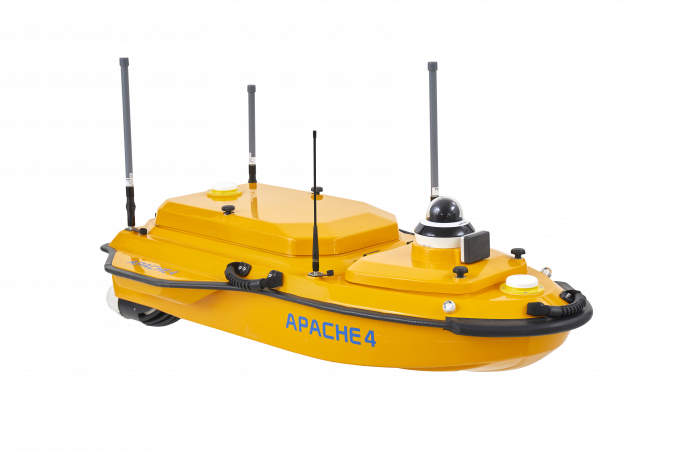
APACHE 4 marine drone
The APACHE 4 marine drone, released to the international market in May 2021, is a compact unmanned surface vessel (USV) featuring a combination of an ADCP (Acoustic Doppler Current Profiler) for cross-sectional flow measurements and a single-beam echosounder. It eliminates the high construction and maintenance costs of the traditional ropeway towing systems used to carry ADCP for cross-section water flow velocity and discharge measurements. The APACHE 4 offers an unattended operation solution with a shallow draft, high navigational accuracy and stable hovering. It is compact, easy to launch and handle on-site, and can be conveniently transported by car.
Key features of the APACHE 4:
Integrated adaptive water flow straight-line and hovering technology.
As water flow and turbulence change, the APACHE 4 autonomously follows the defined profile, navigating in a straight course along the cross section. The hovering technology improves flow estimation accuracy and ensures that the APACHE 4 hovers stably in turbulent flow at the start and endpoint of the ADCP observation.
GNSS+IMU.
The on-board GNSS+IMU module provides uninterrupted positioning and heading data even during transient GNSS signal loss. The obstacle avoidance radar system and live video feed guarantee safe operations in case of loss of visibility or difficult environmental conditions.
Built-in single-beam echosounder.
This allows the user to verify and compensate for the ADCP bottom tracking data accuracy, while providing water depth profile data associated with the flow velocity profile measurement.
Compatible with most ADCPs.
The APACHE 4 can embed different types of ADCP sensors, such as the M9, RTDP 1200, RiverPro or RiverRay while providing them with positioning, orientation, power, waterproofing, local network and 4G transmission.
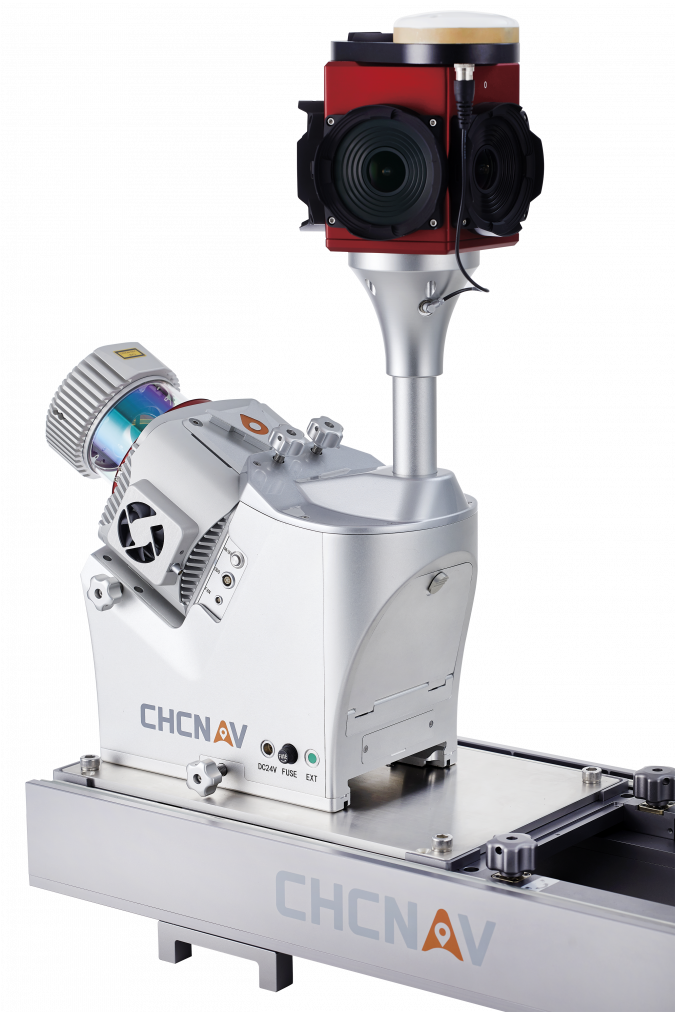
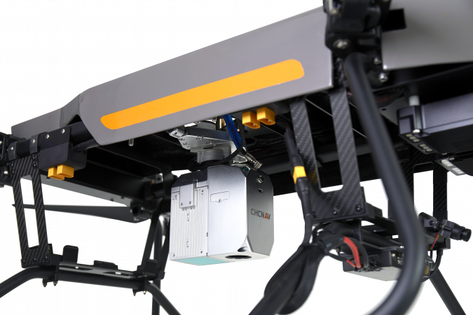
AlphaAir 450, a breakthrough in airborne Lidar affordability
The AlphaAir 450 (AA450) Lidar system is another product that is generating huge interest in CHCNAV innovations. Lidar scanning is an ideal technology for capturing 3D data, but it has long been overly costly and complex to operate. Andrei Gorb of CHCNAV’s Mobile Mapping Division characterizes the AA450 as: “a breakthrough Lidar scanner that delivers user-friendly and high-accuracy capabilities at a reasonable price”. The AA450 is the lightest, most accurate and cost-effective Lidar UAV system in its class. Released to the international market in March 2021, the AA450 integrates a high-performance laser scanner with an industrial-grade professional 26MP camera and a high-precision inertial navigation system. It is widely used for power line inspection, topographic mapping, emergency response, agricultural and forestry surveys and more.
Key features of the AA450:
Lightest in its class.
The AA450 weighs 1kg, making it perfectly suited to drone payload requirements.
Advanced accuracy.
The combination of industrial-grade GNSS with a high-precision IMU means the AA450 easily achieves an absolute accuracy of 5cm (vertical) and 10cm (horizontal) for small survey areas. For even more precision and accuracy, users can apply adjustment algorithms in the CHCNAV CoPre software.
Industrial reliability.
High-level IP64 protection means the AA450 can withstand the challenges of field environments, with operating capability in temperatures from -20℃ to +50℃. This provides more field survey days in a year, increasing users’ return on investment.
Building a smart world with precise spatio-temporal information
CHCNAV offers products, services and end-to-end solutions across seven major industries:
- Surveying & Engineering
- Mobile Mapping & Geospatial
- Marine Surveying
- Navigation & Infrastructure
- Precision Agriculture
- Machine Control
- GNSS OEM
In precision farming, for example, CHCNAV automated steering retrofit kits for tractors are experiencing a phenomenal uptake. Their affordability and ease of use put the efficiencies of precision positioning in the reach of all farms, whatever their size. Powered by local, network or satellite RTK corrections, the GNSS+INS terrain compensation technology provides a hands-free accuracy of ±2.5cm over any terrain.
Digital 3D twins is another area where CHCNAV technologies are pushing frontiers. The purchase of a 3D mobile mapping system is too often constrained to a specific purpose, such as airborne or ground survey. CHCNAV customers expressed a need for a professional Lidar solution that can be used in different scenarios, offering optimal adaptability to their current and future needs. The AlphaUni series is an innovative multi-platform Lidar system that can be used with an aerial or marine drone, on a vehicle or carried as a backpack to provide sophisticated and comprehensive 3D models.
Digital construction breakthroughs on the way
Moving from GNSS Lidar to digital construction is a major next step for CHCNAV. It has a range of technologies for contractors, including machine control for equipment such as excavators and graders, as well as its surveying and site monitoring solutions. At INTERGEO 2022, it will present a full line of solutions that stand out in affordability, while providing dramatic improvements in productivity across work processes and delivering exceptional return on investments.
To find out how CHCNAV’s integrated positioning and navigation solutions can make your work more efficient, contact us at: marketing@chcnav.com.