ScanMaster 2.0
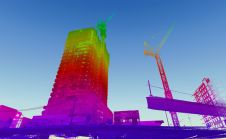
Topcon has announced the release of ScanMaster 2.0 software which is faster and more powerful than previous versions. This new software saves time and increases the productivity on every job,...
Topcon has announced the release of ScanMaster 2.0 software which is faster and more powerful than previous versions. This new software saves time and increases the productivity on every job,...
We all know about the rapid evolution in world mapping. While mapping was long the domain of skilled mapmakers, nowadays it is increasingly in the hands of the lay public,...
Navigation is a daily activity for many as they move from place to place. With increasing complexity in transportation networks has come a rising demand for navigational assistance. Over the...

The AlphaUni 20 (AU20) Lidar system represents a new era in cost-effective, multi-platform mobile mapping solutions, according to CHC Navigation (CHCNav), a global leader in precision mapping, positioning and navigation...

Dassault Systèmes, the 3DEXPERIENCE Company and a world leader in 3D design, 3D digital mock-up and product lifecycle management (PLM) solutions, has announced its takeover of Archividéo, a leader in...

In the ever-evolving landscape of climate change, geospatial science emerges as a key player in navigating the complexities of our transforming world. The European Association of Aerial Surveying Industries (EAASI)...

SingularXYZ has presented its latest innovation for geospatial professionals: the X1 Pro GNSS receiver. This new device aims to refine precision in surveying technology with a range of features tailored...

Woolpert has acquired Murphy Geospatial, a multidisciplinary geospatial solutions company that is headquartered in Kilcullen, Ireland. Murphy Geospatial is a private, family-owned company that delivers a broad range of services...

The Nemetschek Group and Hexagon’s Geosystems division are poised to establish a strategic partnership aimed at accelerating the digital transformation of their industries. As a crucial initial step, the partnership...
When it comes to 3D modelling for construction, what are the advantages and disadvantages of photogrammetry versus Lidar in terms of accuracy, complexity and cost? Breaking away from laser measurement...
This site uses cookies. By continuing to use this website, you agree to our Cookies Policy. Agree