3D Laser Mapping Offers Forensics Workshop
Following the UK launch of a new and innovative hand-held 3D imager, Nottingham-based 3D Laser Mapping has announced a series of workshops designed to promote its benefits. The first workshop...
Following the UK launch of a new and innovative hand-held 3D imager, Nottingham-based 3D Laser Mapping has announced a series of workshops designed to promote its benefits. The first workshop...
Pix4D has developed next-generation software that automatically combines raw images captured by lightweight Unmanned Aerial Vehicles (UAVs) to produce accurate measurements and visualisation of the environment. This enables timely, on-demand...
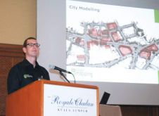
The first event in a series of educational workshops has been hailed as a success by organisers 3D Laser Mapping (UK). Attracting more than 50 practitioners and professionals from public...
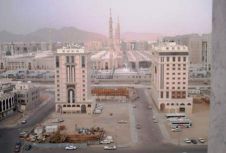
The city of Medina in the Kingdom of Saudi Arabia is realising base maps and 3D modelling. In order to provide the necessary services, Blom CGR, the Italian subsidiary of...
3D Laser Mapping, UK, has announced a new operation in Australia. The new office in Perth will be headed by Iain Bramwell acting as general manager and will provide local...

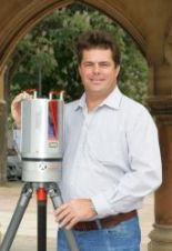
3D Laser Mapping, UK, has appointed Adriaan Oeschger to the position of Key Account Manager. Oeschger's surveying background dates back more than twenty years working in the mining industry and...
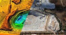
A laser scanning system is to improve safety of iron ore extraction in South Africa. The Riegl laser scanner forms an integral part of a Waste Spreader Positioning System (WSPS)...
3D Laser Mapping has opened a new global headquarters near Nottingham, UK, following continued expansion of its worldwide laser scanning solutions business. This relocation to larger premises will allow for...
StreetMapper is available with four unique system specifications offering users a flexible solution for gathering highly accurate 3D laser measurements on the move. Ranging from dedicated survey vehicles to portable...
3D Laser Mapping has appointed Francois Stroh to the position of global mining product manager. Stroh, an engineering surveyor with more than ten years experience of laser scanning sales, installation,...
This site uses cookies. By continuing to use this website, you agree to our Cookies Policy. Agree