A Company with Direction
iXSea's strength is in technology. Of its roughly 200 employees, a third are engaged in R&D. The company holds 21 key patents in the area of navigation and positioning -...

iXSea's strength is in technology. Of its roughly 200 employees, a third are engaged in R&D. The company holds 21 key patents in the area of navigation and positioning -...

‘Cada hombre es el hijo de sus propios trabajos' - ‘every man is the son of his own works', from Don Quixote by Cervantes. Works of Spanish cartography, as reflected...
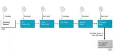
Technically speaking, natural disasters cannot be prevented, but potential disaster can be managed to minimise loss of life and goods. Disaster Management (DM) covers mitigation, preparedness, response and recovery. The...
NOAA's Office of Oceanic and Atmospheric Research and Google have signed a cooperative research and development agreement outlining how they will work together to create state-of-the-art visualizations of scientific data...
As William Pollard said, "Information is a source of learning. But unless it is organised, processed, and available to the right people in a format for decision making, it is...
Caris (Canada) has established a regional office in Australia to maximise support of its rapidly growing Asia Pacific customer base and expand its presence in this market. Caris, a developer...
As the fast growth of Web-GIS produces more and more applications requiring data stored at remote databases, data access security and data transfer speed over the internet are at issue....
This month we bring you an extended interview with engineer Pedro Pedreira, executive director of the European Global Navigation Satellite System Supervisory Authority (GSA)since July 2005, the body charged with...
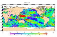
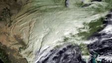
Less than a month after launch, the NASA-French space agency Ocean Surface Topography Mission (OSTM)/Jason 2 oceanography satellite has produced its first complete maps of global ocean surface topography, surface...
Galdos Systems Inc. (Canada) and TENET Defence Ltd (UK) have successfully completed the integration of multiple geospatial data across the UK Ministry of Defence into a single source through the...
This site uses cookies. By continuing to use this website, you agree to our Cookies Policy. Agree