Disaster Mapping 2.0
There has been a recent increase in the incidence of major disasters and the damage caused, in terms both of human suffering and economic cost. UNOSAT Mapping The main goal...
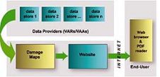
There has been a recent increase in the incidence of major disasters and the damage caused, in terms both of human suffering and economic cost. UNOSAT Mapping The main goal...
TatukGIS has released the 2.0 upgrade of its desktop GIS Editor product with new features such as advanced support for coordinate systems, many new data formats, and scripting for customising...
Satellite imagery provider DigitalGlobe (CO, USA) today released Citysphere 2.0, an enhanced version of its library of on-demand digital satellite imagery of the most populated global cities. CitySphere 2.0 features...
ScanEx R&D Center (Russia) has released version 2.0 of ScanMagic software, designed for Earth remote sensing data processing. The updated version supports popular cartographic services of Google, Microsoft and Yahoo....
Leica Geosystems (Swizerland) has released Leica MobileMatriX version 2.0; a multi-sensors GIS solution for capturing GIS data directly in the field. The new version 2.0 now supports Leica ATX1230 GG...
Leica SpiderWeb version 2.0 has been extended with additional features and services that improve the usability and efficiency for both service users and service providers. Leica SpiderWeb is easy to...
Version 2.0 of Leica GeoMoS has been released. This is a solution for multi-sensor structural monitoring using a range of high precision geodetic instruments from Leica Geosystems and third-party sensors....
DM Solutions Group (Canada) has made available Chameleon version 2.0, an Open Source software for creating customisable Web mapping applications. This latest version provides the flexibility to utilise both remote...
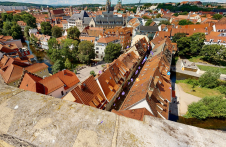
Lidar-powered Matterport technology was employed to create a 3D digital twin of the most famous inhabited bridge globally, the Krämerbrücke, situated in the city of Erfurt, Thuringia, Germany. The Krämerbrücke...
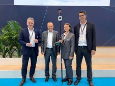
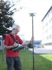
The Leica AP20 AutoPole received the prestigious Wichmann Innovations Award at this year’s Intergeo in Essen, Germany. The award honours new technology that stands out for innovation, user-friendliness and practicality....
This site uses cookies. By continuing to use this website, you agree to our Cookies Policy. Agree