YellowScan Lidar for Drone 2016 User Conference
YellowScan has put together a diverse agenda for the YellowScan Lidar for Drone 2016 User Conference. The topics on the programme prove the broad usage of YellowScan Lidar equipment in...
YellowScan has put together a diverse agenda for the YellowScan Lidar for Drone 2016 User Conference. The topics on the programme prove the broad usage of YellowScan Lidar equipment in...
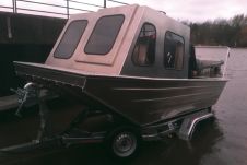
Surveying Britain’s 2000 miles of inland waterways is specialised work. Kate Rowlatt and John Williams show how a new compact custom system aboard a bespoke survey vessel is capturing cleaner...
YellowScan ha anunciado el lanzamiento global de su nueva solución para levantamientos con UAS Lidar, de alta precisión y mayormente denso para datos de nube de punto georrefenciados. Pesando sólo...

At ILMF 2016 in Denver, Colorado, USA, RIEGL launched two new high-speed mobile mapping turnkey systems featuring the high-performance VUX-1HA kinematic Lidar sensor. The first customers in the United States...
On 22 February at ILMF 2016 in Denver, RIEGL launched two high-speed mobile mapping turnkey systems featuring the VUX-1HA kinematic LiDAR sensor. RIEGL is proud to announce the first launch...
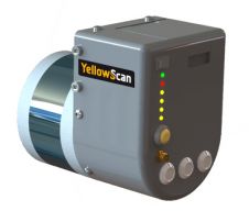
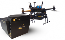
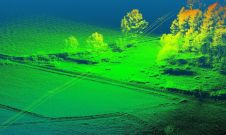
YellowScan is pleased to announce the global launch of its new Lidar UAS surveying solution with its highest accuracy and most dense geo-referenced point cloud data: 3cm accuracy – 300...
YellowScan has announced the global launch of its new Lidar UAS surveying solution with highest accuracy and most dense georeferenced point cloud data. Weighing only 1.5kg, the YellowScan Surveyor has...

Back in 2012, Siteco – an Italian developer of Lidar mapping systems – won the Friuli Venezia Giulia Region tender in its home country by designing and developing a special model of...

Trimble Applanix designs, builds, delivers and supports products and solutions designed specifically for the hydrographic survey industry. Our products and solutions provide robust, reliable and repeatable positioning and motion compensation...

The UAV-g 2015 International Conference of Unmanned Aerial Vehicles in Geomatics, with the theme 'Small Unmanned Aerial Systems (sUAS): A Disruptive Technology for Geomatics' was held at York University, Toronto,...
This site uses cookies. By continuing to use this website, you agree to our Cookies Policy. Agree