Trimble Dimensions 2007
Trimble Dimensions 2007 took place from 5th to 7th November 2007 at the Convention Center and Events Center, Mirage Hotel, Las Vegas, US. There were some 2,200 participants, up from...
Trimble Dimensions 2007 took place from 5th to 7th November 2007 at the Convention Center and Events Center, Mirage Hotel, Las Vegas, US. There were some 2,200 participants, up from...
INPHO (Germany) has updated and integrated their software into a complete, perfectly tuned and integrated system. MATCH-AT 5.0, MATCH-T 5.0, DTMaster 5.0 and OrthoMaster 5.0 are released at one time,...
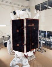
Ball Aerospace & Technologies Corp., ITT Corporation and DigitalGlobe have announced delivery of its WorldView-1 satellite to Vandenberg Air Force Base in California for its scheduled launch on Tuesday, 18th...
Hewlett Packard (HP) celebrates the twentieth anniversary of its Barcelona site this year. The company has a portfolio spanning printing, personal computing, software, services and IT infrastructure, and Barcelona is...
More than five hundred exhibitors from 32 countries are due to put in an appearance at Intergeo 2008, presenting a comprehensive overview of the geo(infor)matics business today. Covering a wide...
Terrestrial laser scanning combines a high level of detail with surveying accuracy for the creation of 3D-models of virtually any object. The technology literally opens up new dimensions and so...

DigitalGlobe (CO, USA) has successful launched and deployed WorldView-1. The satellite launched at approximately 11:35 AM PDT on a Boeing Delta II 7920 rocket from Vandenberg Air Force Base in...
Magellan (France) has introduction the DG14 RTK which offer high-end precision in a low-cost GNSS unit. The DG14 RTK from Magellan is a cost-effective, sub-metre GNSS (GPS and SBAS) and...
ArWest Communications Corporation (CA, USA) has been awarded a contract by Topcon Positions Systems to provide 1 Watt UHF transceivers integrated within the Topcon GR-3 triple constellation RTK Satellite Receiver....
The April 2008 issue of GIM International (page 11) summarised a project to map the Maldives as an example of how aerial photogrammetry is today applied for mapping large, complex...
This site uses cookies. By continuing to use this website, you agree to our Cookies Policy. Agree