Webinar: How to accurately merge imagery with Lidar
This webinar will present the following: - Importing LiDAR point clouds - Registering LiDAR data and images automatically - Orthorectifying on LiDAR DEMs - Colorizing LiDAR point clouds
This webinar will present the following: - Importing LiDAR point clouds - Registering LiDAR data and images automatically - Orthorectifying on LiDAR DEMs - Colorizing LiDAR point clouds

UP42 has announced that image data and information from the planned LatConnect 60 constellation of mid-inclined orbit remote sensing satellites will be available on the UP42 developer platform for Earth...

SimActive has announced the release of Correlator3D version 8.6. The new version includes multiple new features, such as the use of intensity data from LAS files for image registration, the...

Read this farewell interview with Mathias Lemmens, who is stepping down from GIM International after 23 years as senior editor and industry figurehead. After 23 years, senior editor and industry figurehead...
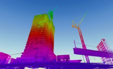
When it comes to 3D modelling for construction, what are the advantages and disadvantages of photogrammetry versus Lidar in terms of accuracy, complexity and cost? Breaking away from laser measurement...
A recurring sustainable issue faced by the architecture, engineering and construction (AEC) industry is that of green buildings. The global market for green construction is projected to reach US$364.6 billion...
TatukGIS recently implemented support for geological 3D maps for incorporating multiple, vertically spaced digital elevation models and other layers in the same map project. This was done in response to...
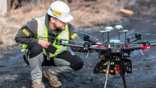
YellowScan, a market leader in UAV Lidar mapping solutions, has announced a new distribution partnership with Beijing MapCore Technology. MapCore is known as a company with extensive experience in survey...
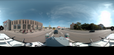
Large amounts of personal data, such as faces and number plates, are collected during mobile mapping. Receiving consent from individuals for large-scale data collection is not feasible but is required...
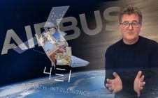
Earth observation company 4 Earth Intelligence (4EI) is partnering with Airbus Defence and Space to release the power of Airbus very high resolution satellite imagery for applications such as climate...
This site uses cookies. By continuing to use this website, you agree to our Cookies Policy. Agree