ZZCOMM Technology Co Ltd
Founded in 2017, ZZCOMM technology of geospatial hardware and software solutions provides rapid and high-accurate geospatial data for BIM, mining AEC, survey and mapping industries, whether they are indoor, outdoor,...

Founded in 2017, ZZCOMM technology of geospatial hardware and software solutions provides rapid and high-accurate geospatial data for BIM, mining AEC, survey and mapping industries, whether they are indoor, outdoor,...
ORBIMAGE Holdings Inc. (VA, USA) has finalised the acquisition of substantially all of Space Imaging’s (CO, USA) assets. The combined company will now do business under the brand name GeoEye....
The National Geospatial-Intelligence Agency (NGA) has awarded a US$24-million satellite imagery contract extension to Space Imaging. This ClearView contract option enables the NGA to acquire additional commercial imagery from Space...
Space Imaging (CO, USA) has announced it will soon offer satellite ground station access and sell imagery from Indian Space Research Organization's (ISRO) newest satellite CARTOSAT-1 (P-5), which has been...
Space Imaging Middle East (SIME) (Dubai) signed a co-operation agreement with Khatib&Alami (K&A) (Lebanon), a multidisciplinary architectural and engineering consulting company with long-term expertise in GIS. SIME will become K&A’s...
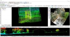
Making their European debut, LP360 and the all-new TrueView 655/660 will be exhibited at Intergeo 2022. The TrueView 655/660 is GeoCue’s third-generation RIEGL integration built with the miniVUX-3UAV and triple...

A new strategic partnership between Umbra and European Space Imaging (EUSI) will allow customers to purchase Umbra’s industry-leading synthetic aperture radar (SAR) data directly through EUSI. Umbra is a leader...

Detlef Angermann holds a doctorate in Geodesy and heads the Focus Area Reference Systems at the Deutsches Geodätisches Forschungsinstitut (DGFI-TUM) of the Technical University of Munich. His research focuses on...

Global reference systems such as the International Terrestrial Reference Frame provide the foundation for determining positions on Earth and in space, as well as for reliably quantifying our planet’s changes...
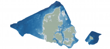
Through the collaborative implementation of satellite-derived bathymetry (SDB), the Danish Geodata Agency and EOMAP are synergizing efforts to contribute to the European Marine Observation and Data Network (EMODnet) Bathymetry partnership....
This site uses cookies. By continuing to use this website, you agree to our Cookies Policy. Agree