European Space Imaging unveils new brand identity as EUSI
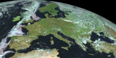
European Space Imaging has recently rebranded to the acronym of EUSI. The decision to modernize the company's brand was made to reflect its commitment to innovation and the reliability of...

European Space Imaging has recently rebranded to the acronym of EUSI. The decision to modernize the company's brand was made to reflect its commitment to innovation and the reliability of...
The Open Maps For Europe 2 (OME2) project has revealed plans to boost the utilization of European cadastral data. This includes efforts to enhance its discoverability and accessibility. As part...
Blue Marble Geographics has released GeoCore 2.0, the conversion developer tool kit for geospatial data. The updated version of GeoCore includes the latest versions of GeoTransform, GeoCalc, and GeoTranslate software...
Topcon has announced the release of ScanMaster 2.0 software which is faster and more powerful than previous versions. This new software saves time and increases the productivity on every job,...
Navigation is a daily activity for many as they move from place to place. With increasing complexity in transportation networks has come a rising demand for navigational assistance. Over the...
We all know about the rapid evolution in world mapping. While mapping was long the domain of skilled mapmakers, nowadays it is increasingly in the hands of the lay public,...

Diamond Aircraft and Vexcel Imaging have announced the next collaboration for a further expansion of Diamond’s special mission aircraft high-end sensor portfolio. The partnership will integrate the UltraCam Dragon 4.1...

SI Imaging Services (SIIS) is gearing up for the launch of an innovative 100%-commercial optical satellite with high-end resolution capabilities. This strategic initiative, in collaboration with its parent company Satrec...

The brand-new United Nations Global Geodetic Centre of Excellence (UN-GGCE) is now operational at the United Nations campus in Bonn, Germany. Nicholas Brown, head of office of the UN-GGCE, is...

The Australian government has committed to participating in Landsat Next, a groundbreaking satellite initiative spearheaded by NASA and the US Geological Survey. This programme aims to comprehensively map and monitor...
This site uses cookies. By continuing to use this website, you agree to our Cookies Policy. Agree