Geomatics 2.0
We all know about the rapid evolution in world mapping. While mapping was long the domain of skilled mapmakers, nowadays it is increasingly in the hands of the lay public,...
We all know about the rapid evolution in world mapping. While mapping was long the domain of skilled mapmakers, nowadays it is increasingly in the hands of the lay public,...
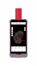
ComNav Technology has introduced its new handheld P6H. This advanced and rugged device is tailor-made for GIS data collection and outdoor operations. Featuring a GNSS high-precision positioning module, rugged IP67-rated...

Over the past 20 years, various initiatives have been launched reflecting the importance of cadastral data for land management and spatial development. But how have these initiatives enhanced the possibility...

CyArk, a non-profit organization dedicated to recording, archiving and sharing the world’s cultural heritage is announcing a partnership with FARO Technologies, Inc., the world’s most trusted source in 3D measurement,...
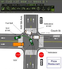
FARO has announced the release of FARO Zone 2D, a completely new diagramming software for law enforcement, fire service, and insurance professionals. FARO Zone 2D is the next generation diagramming software...

FARO Technologies, manufacturer of 3D measurement, imaging, and realisation technology, has announced the acquisition of Kubit, specialised in the development of software for surveying and as-built documentation. The takeover also...
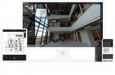
FARO Technologies has announced the acquisition of HoloBuilder and its leading photogrammetry-based 3D platform which delivers hardware-agnostic image capture, registration and viewing to the fast-growing digital twin market. FARO Technologies...
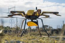
YellowScan, a familiar name in the mapping and land surveying realm, is making a noteworthy entrance in the hydrographic sector with the introduction of its pioneering UAV-based bathymetric Lidar solution....
This site uses cookies. By continuing to use this website, you agree to our Cookies Policy. Agree