Avia-GIS

From the skies to the ground, aerial surveying and mapping professionals play a crucial role in capturing, processing, analysing and publishing geospatial data. This article explores the diverse career opportunities...
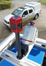
StreetMapper GIS, a new version of the mobile laser mapping system with an integrated panoramic camera, has been launched by 3D Laser Mapping and IGI mbH. StreetMapper GIS is easy...
This month we focus on maps and GIS for Early Warning (EW) and Emergency Management (EM): good maps are proven fundamental basics for tackling chaos after tragedies, and GIS plays...
Among the many displays and interactive activities at the new Sam J. Racadio Library and Environmental Learning Center in Highland (CA, USA), is a geographic information system kiosk. The kiosk,...
(Geo-)information is an essential asset for managing protected areas. Although plenty of (geo-)information is in place today, the challenge is to bring it to widely distributed users. The authors developed...
GIS software is usually customised using intrinsic programming and writing scripts in conventional programming languages. Since these scripts are run through an interpreter they are slower to execute than well-implemented,...
This site uses cookies. By continuing to use this website, you agree to our Cookies Policy. Agree