Addressing recruitment challenges in the aerial surveying industry
Concerns about the evolving landscape of geomatics studies
From the skies to the ground, aerial surveying and mapping professionals play a crucial role in capturing, processing, analysing and publishing geospatial data. This article explores the diverse career opportunities within aerial surveying against the backdrop of recruitment challenges and concerns about the evolving landscape of geomatics studies.
Although the first photogrammetric cameras were invented 100 years ago, aerial mapping has not been immune to the technological advances that have radically transformed the industry in the last 20 years. The most recent developments have expanded the possibilities within aerial surveying. From utilizing advanced sensors and cameras to integrating Lidar and photogrammetry techniques, professionals are at the forefront of innovation. They constantly adapt to new tools and methodologies to capture data more precisely and efficiently. This continuous learning and exploration make aerial surveying an intellectually stimulating field that pushes boundaries and fosters professional growth.
Key roles in aerial surveying
In the crewed aerial surveying industry, numerous professionals collaborate to ensure accurate data collection and analysis. Some of the key roles include:
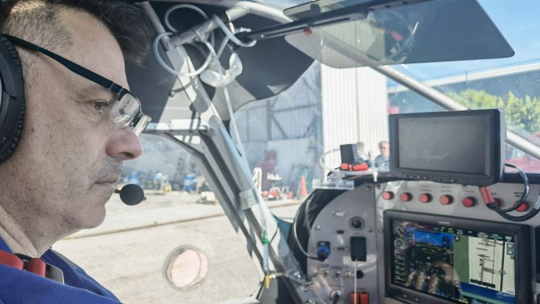
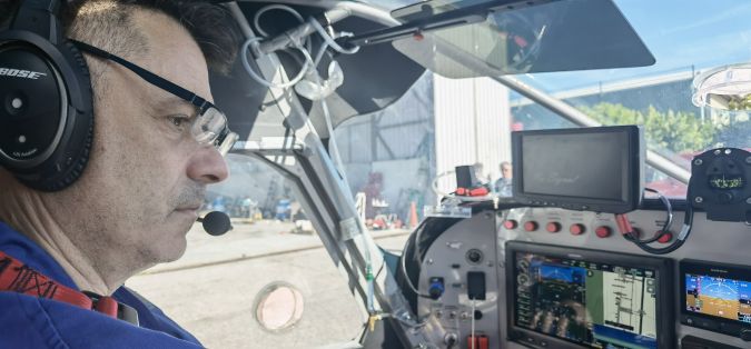
- Aerial survey pilots: Skilled pilots fly specific aircraft equipped with advanced cameras and sensors to capture high-resolution data for mapping and surveying projects. They are usually in charge of managing flight permits and coordination with air traffic control.
- Camera operators/aerial survey technicians: These technicians are responsible for operating and installing the cameras, sensors and other equipment used during aerial surveying flights. They are also responsible for flight planning to meet the project’s requirements.
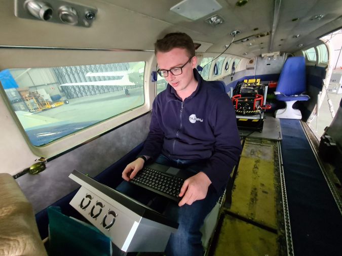
- Image processing specialists: Experts in aerial imagery who analyse and process the images to ensure quality and usability.
- Survey engineers: These professionals are the ones responsible for taking measurements on the ground. These measurements are required to guarantee the quality and accuracy of the data captured from the air and its integration with ground-based mapping activities.
- Photogrammetrists: Using specialized software, these professionals convert aerial imagery into three-dimensional models, orthophotos and maps. Their expertise in image analysis and manipulation enables the transformation of visual data into accurate geospatial information.
- Lidar specialists: Leveraging light detection and ranging (Lidar) technology, these specialists process highly precise data about the Earth’s surface, including terrain, vegetation and buildings. They play a crucial role in point cloud adjustment and classification.
- Cartographers and GIS experts: These technicians transform the 3D data into meaningful maps, urban 3D models, digital twins, etc., supporting decision-makers in their work.
- Data analysts: Skilled in working with extensive geospatial datasets, data analysts extract insights, identify patterns and create visualizations.
Recruitment challenges
As the list of key roles shows, there is more to aerial surveying than just skilled pilots. Working in this field calls for a solid understanding of geodesy, photogrammetry and cartography. Professionals involved in aerial surveying need a solid background in geomatics to understand aerial imagery, sensor technology and geospatial data. Given these high demands, perhaps it should come as no surprise that the industry is facing increasing challenges to find, attract and retain talent, particularly among geomatics professionals.

Connecting with the next generation at the IGSM
Recognizing the need to connect with the next generation, the European Association of Aerial Surveying Industries (EAASI) actively participates in initiatives that aim to attract potential professionals to the aerial surveying profession. One such initiative is the sponsorship of the International Geodetic Student Organisation Meeting (IGSM). This gathering brings together worldwide students and recent graduates of geodesy.
The latest edition of the event took place in Valencia, Spain, from 2 to 8 July 2023, with representation from over 20 universities primarily based in Europe. During the event, the EAASI secretary general, Marcos Martínez-Fernández, participated in a roundtable discussion alongside industry representatives, academics and students. This open dialogue shed light on the evolving landscape of geomatics studies. Many students expressed their concerns about the growing trend of new interdisciplinary programmes which include geomatics in combination with other branches of knowledge, resulting in a slow fading of the core studies. They warned that this shift could potentially lead to graduates with programming skills being preferred over those with a specialized geomatics background when looking for a job.
The diversification of geomatics studies
The topic of the progressive diversification of geomatic studies is not a new one. According to Fabio Remondino, head of the 3DOM research unit at the Fondazione Bruno Kessler and vice-president of European Spatial Data Research (EuroSDR), the challenges faced in recruiting highly specialized geomatics profiles can partly be attributed to changes introduced by the Bologna Plan. This has impacted geomatics curricula and influenced the direction of the field, he believes. With universities offering a broad range of interdisciplinary master’s programmes, students face the dilemma of selecting a specific field of study. Many of these programmes place a heavy emphasis on practical work with software tools, leaving students lacking in theoretical knowledge and critical thinking skills.
This trend poses challenges in attracting students to the academic and research world, as the magnetism of broad, practical skills may overshadow the importance of foundational knowledge. It is a topic of concern for the students, the research community and the industry at large. Many representatives from both the public and private sectors have stressed the critical importance of aerial surveying professionals having specialized geodetic knowledge.
Desires and expectations
Besides requiring professionals with the right knowledge and skills, the further growth of the aerial surveying industry is dependent on all stakeholders listening to the voices of the next generation, collaborating and adapting to the changing landscape. It is important to understand the perspectives of students and young graduates, since their input and concerns shape the future of the industry. A survey conducted by EAASI during the IGSM revealed that, while salary remains an important criterion in job selection, other factors such as work-life balance and opportunities for remote working also held significance for the students. By considering the desires and expectations of the emerging generation, the industry can design attractive career paths that align with their aspirations and values.
Conclusion
In line with the broader geospatial field, the field of aerial surveying faces challenges in recruiting highly specialized professionals with a geomatics background. The convergence of disciplines and changes in educational curricula have impacted the availability of dedicated geomatics courses. To address these challenges and ensure a thriving industry, enhanced collaboration between the private sector, public sector and academia is crucial. By fostering partnerships, sharing knowledge and providing opportunities for joint research and development, it will be possible to bridge the gap between evolving educational landscapes and the specialized needs of the aerial surveying profession.
What’s a career in aerial surveying really like?
In the world of aerial surveying, skilled professionals play a vital role in capturing geospatial data from the skies to contribute crucial information to a wide range of projects and initiatives. Here, two member companies of EAASI shed light on their real-life experiences and provide insights into what it’s really like to work in the industry.
Bluesky International
Bluesky International is a UK-based specialist aerial survey and geographic data company, producing and maintaining high-quality, accurate digital aerial photography and height data on a national scale in both Great Britain and the Republic of Ireland. The company, which was founded in 2003, interviewed some of its employees to offer insights into the daily working lives of two key roles within aerial surveying: the airborne operator and the Lidar supervisor.
- The airborne operator’s day-to-day tasks can vary significantly, from capturing data in the skies to office-based work such as flight planning and project organization. The greatest rewards stem from successfully completing surveys and bringing valuable data home, despite the challenges posed by weather conditions and project complexities.
- The Lidar supervisor is responsible for overseeing Lidar processing, preparing deliverables such as digital elevation models (DEMs) and point clouds, and assisting with project management. The role involves collaborating closely with a dedicated team and ensuring the timely and accurate delivery of data to customers.
To excel in both these professions, certain skills and qualities are crucial. Motivation, adaptability and organizational skills are highly valued in the ever-changing and weather-dependent world of aerial surveying. A willingness to learn and a good understanding of weather patterns are also advantageous for those looking to enter this field.
Sixense Helimap
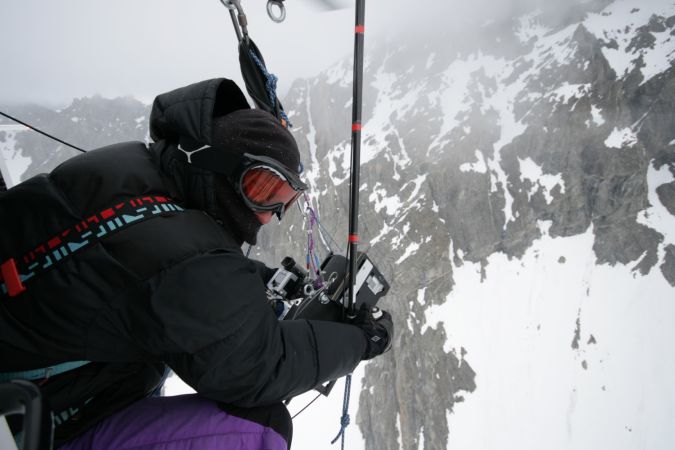
Sixense Helimap, a member of the Sixense group (VINCI Construction), is a Swiss company that specializes in Lidar and photogrammetric data acquisition and processing services. Helimap’s work is distinguished by an element of adventure, since it conducts geospatial data acquisition missions via helicopters, ultralights or terrestrial vehicles. Helimap covers all continents, from New Caledonia to Mexico and Africa to Europe. With a fleet of eight full LiDAR@Photo technology kits, the company possesses the versatility to adapt to various scenarios, including Alpine glaciers, dense tropical forests and vast African plains. The company’s licence to operate outside of helicopters allows it to capture data from shaded or challenging areas that are otherwise difficult to access. This company provided EAASI with an overview of the role of a project manager.
- At Helimap, each project is meticulously managed by a dedicated project manager who oversees the entire process, from planning to data processing. These professionals actively participate in missions aboard helicopters, ensuring the accurate acquisition of Lidar and photogrammetric data. This close involvement enables Helimap’s staff to work in diverse environments, stay connected to the unique requirements of each project, and continuously learn from a job where no two days are alike.

Value staying current with geomatics?
Stay on the map with our expertly curated newsletters.
We provide educational insights, industry updates, and inspiring stories to help you learn, grow, and reach your full potential in your field. Don't miss out - subscribe today and ensure you're always informed, educated, and inspired.
Choose your newsletter(s)


