Updating the Cadastre in Ecuador
Photogrammetry and Lidar were used together in Ecuador to detect irrigation and drainage canals for a project aiming to improve irrigation methods and create the related land registry. The integration...
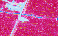
Photogrammetry and Lidar were used together in Ecuador to detect irrigation and drainage canals for a project aiming to improve irrigation methods and create the related land registry. The integration...

Trimble has announced the launch of the latest addition to its portfolio of data collectors – the Trimble T7 tablet. Purpose-built for survey and GIS data collection applications, the next-generation...
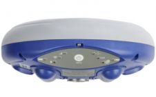
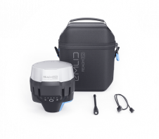
Carlson has launched a lightweight surveying receiver that utilizes all four constellations and provides triple-frequency tracking. The Carlson NR3 was introduced by Carlson Software President and Founder Bruce Carlson. Weighing...

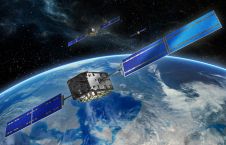
The European navigation system Galileo is suffering a major outage. The satellite network has been largely down since Friday 12 July due to a technical incident related to its ground...
“On Tuesday, 18 July 2019, technical weather is forecast as I get into my car on my way to an important GNSS verification test. Yesterday I received a short e-mail...
At the company's 'Grow With Us' User Conference 2019, Carlson Software's president and founder Bruce Carlson introduced the Carlson NR3 network rover. Weighing in at just under two pounds, the...

Trimble has introduced the Trimble TDC600 handheld, an ultra-rugged, all-in-one smartphone and GNSS data collector for GIS and field inspection applications. The next-generation smartphone data collector boasts an Android 8.0...
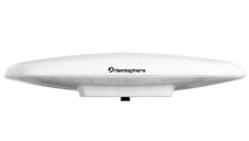
Hemisphere GNSS have announced a single-frequency, multi-GNSS Vector V200 smart antenna with integrated Atlas L-band designed for general marine applications and markets. Powered by Hemisphere's Crescent Vector technology, the V200...
Emlid, the creators of Reach, a centimetre-accurate RTK GNSS receiver, recently launched their multi-band GNSS receiver Reach RS2. The new receiver features built-in LoRa radio, 3.5G modem and a survey...

The 13th International Navigation Forum will open its doors to recognized world-class experts in the field of navigation technologies at Expocentre Fairgrounds in Krasnaya Presnya, Moscow, Russia, from 23-24 April...
This site uses cookies. By continuing to use this website, you agree to our Cookies Policy. Agree