GIM - Issue 2-2024
Presenting the latest developments in aerial mapping, products and services. Intriguing real-life projects provide insights into advanced aerial photogrammetry and Lidar in practice. Moreover, this edition looks at how AI...

Presenting the latest developments in aerial mapping, products and services. Intriguing real-life projects provide insights into advanced aerial photogrammetry and Lidar in practice. Moreover, this edition looks at how AI...

Fujitsu has presented a pioneering technology that harnesses Lidar and AI to capture high-resolution 3D data of organisms, coral reefs and man-made structures such as offshore wind turbines using autonomous...

Despite some uncertainty, there is renewed interest in drones, and remote sensing technologies are being embraced by smaller survey companies. Read these and other findings from our annual industry survey!...

The Earth observation industry seems to be on a slow burn – but why? Brace yourself for a ‘rollercoaster ride’ through Earth observation as this article unravels the mysteries behind...

The Faroese Environment Agency, responsible for national mapping activities including land mapping and hydrographic surveying, has recently joined EuroGeographics, the representative body for European national mapping, cadastral and land registration...

Inertial Labs and Sony have joined forces to develop an advanced Lidar system tailored for Sony's Airpeak drone. This collaboration aims to enhance drone capabilities in applications such as surveying,...
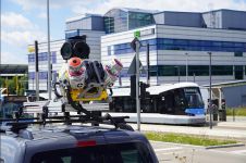
Klau Geomatics has introduced the Brumby RTK Lidar system, an innovative mobile mapping solution equipped with powerful Edge Compute capabilities, enabling the generation of highly precise georeferenced point clouds in...
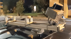
Trimble has recently unveiled the Trimble MX90 mobile mapping system. Integrating advanced Trimble GNSS and inertial technology with Trimble field and office software, the MX90 offers a comprehensive field-to-finish mobile...

In the ever-evolving landscape of climate change, geospatial science emerges as a key player in navigating the complexities of our transforming world. The European Association of Aerial Surveying Industries (EAASI)...

Woolpert has acquired Murphy Geospatial, a multidisciplinary geospatial solutions company that is headquartered in Kilcullen, Ireland. Murphy Geospatial is a private, family-owned company that delivers a broad range of services...
This site uses cookies. By continuing to use this website, you agree to our Cookies Policy. Agree