
Trimble launches MX90 mobile mapping solution
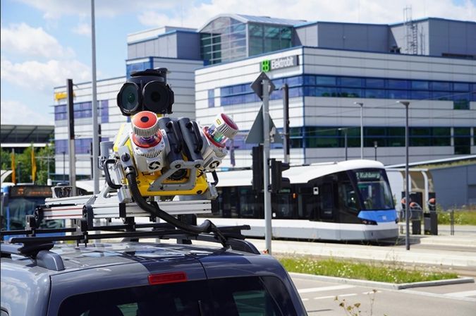
Trimble has recently unveiled the Trimble MX90 mobile mapping system. Integrating advanced Trimble GNSS and inertial technology with Trimble field and office software, the MX90 offers a comprehensive field-to-finish mobile mapping solution. The solution is presented as a new standard in mobile mapping technology, empowering robust workflows for data capture, processing and analysis.
The MX90, mounted on vehicles or trains, swiftly captures detailed laser scans and imagery – panoramic and multi-angle. This data, collected at highway speeds, undergoes rapid processing to produce meaningful deliverables for feature detection and inspections. With peak performance, unrivalled location accuracy and robust cameras, it delivers precise, feature-rich data essential for various workflows.
High-resolution immersive imagery, high-density colourized point clouds with accurate colour projections and scene inspection capabilities enable new workflows, such as automatic crack detection. In urban environments or along rail tracks, zoom in and easily see small details on street signs, railway signals and other assetsor as-built features. In open areas and large cities, capture more detail on distant objects, such as electrical or fibre poles.
Wide range of deliverables
The Trimble MX90 boasts several notable features. The new mobile mapping system includes immersive 360-degree panoramic and targeted cameras to capture high-resolution imagery of various details, such as small or distant road and rail signs, telecommunications towers, or cracks and holes in roads. Additionally, it offers high-density colourized point clouds with rich and accurate colour projections, achieved through the collection of more pixels. These dense point clouds, along with high-resolution imagery (panoramic and planar) and accurate trajectories, provide the basis for a wide range of deliverables, including street scenes, road and rail asset details, elevation models, volume calculations, 3D city models and as-built surveys.
Furthermore, the system features a high-end IMU, combined with IN-Fusion+ data processing technology, to achieve high-quality data in challenging GNSS environments. It also comes with reliable office software solutions to support multiple use cases and applications, such as road inspection workflows and integration into cloud-based applications for efficient data sharing.
To learn more about the Trimble MX90 mobile mapping system, see here.

Value staying current with geomatics?
Stay on the map with our expertly curated newsletters.
We provide educational insights, industry updates, and inspiring stories to help you learn, grow, and reach your full potential in your field. Don't miss out - subscribe today and ensure you're always informed, educated, and inspired.
Choose your newsletter(s)


