New Leica Scanner Hits the Market
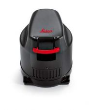
Leica Geosystems launched its new Leica ScanStation C5 Laser Scanner at the recent Hexagon 2011 Conference. The compact scanner provides professionals with a combination of Leica Geosystems quality scan data...

Leica Geosystems launched its new Leica ScanStation C5 Laser Scanner at the recent Hexagon 2011 Conference. The compact scanner provides professionals with a combination of Leica Geosystems quality scan data...
Leica Geosystems, Switzerland, has released the Leica RCD30, the first metric medium-format 60MP camera to acquire co-registered multispectral four-band imagery in RGB and NIR for photogrammetric and remote sensing mapping...

Mass migration from rural areas to cities, population growth and therefore increasing need for oil and gas, but also food, infrastructure like roads and railways: all form a basis for...
Intergraph attracted 5,500 delegates to its global series of 2011 user group conferences for the process, power and marine industries. User conferences were held in 25 countries on six continents...

Intergeo 2012 has come to an end. This year’s edition took place in Hanover, Germany and attracted 16,000 trade show visitors. 520 companies exhibited, bringing their latest innovations and trends...
Leica Geosystems, headquartered in Switzerland, and GeoCue, from the USA, have entered into a strategic collaboration to create integrated geospatial workflow solutions for the professional mapping market. According to Jack...

GeoMax Zenith 10&20 RTK GNSS – a flexible system with all communication devices integrated. When GeoMax arrived on the international stage in 2008, many experts doubted whether there was room...

Earth imaging from air and space has undergone major changes in recent years. Examples of new and significant developments comprise the advancement of digital aerial cameras, laser scanners and UAVs...

Merrick & Company, based in Colorado, USA, has won the first place in the civil/survey category of the 'High Definition Surveying (HDS) Plan' contest, hosted by Leica Geosystems. The annual...
The City of Edmonton, Canada, has chosen Intergraph to provide ongoing access to the latest geospatial software and services through a multi-year agreement. Intergraph’s North American Site License gives Edmonton...
This site uses cookies. By continuing to use this website, you agree to our Cookies Policy. Agree