GIM International Attends UAV-g 2013
The Unmanned Aerial Vehicles in Geomatics (UAV-g) conference 2013 is taking place this week in Rostock, Germany. UAS professionals from all over the world will be gathering in the city,...

The Unmanned Aerial Vehicles in Geomatics (UAV-g) conference 2013 is taking place this week in Rostock, Germany. UAS professionals from all over the world will be gathering in the city,...

Geo-matching.com, the product comparison website for devices used in geomatics, hydrography and related industries, has announced the addition of a new category for Unmanned Aerial Systems. The types of Unmanned...
My name is Laura Norman. I am currently entering my fourth year of geomatics engineering at the Schulich School located in the University of Calgary, Alberta Canada. I have been...
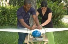
The popularity of unmanned aerial systems (UAS) is on the rise in many countries for a multitude of applications. In one such development, the UAS is rapidly becoming a tool...
The popularity of unmanned aerial systems (UAS) is on the rise in many countries for a multitude of applications. In one such development, the UAS is rapidly becoming a tool...

With a focus on hydrographic topics and the at times apocalyptic wetter side of life, there is still space for tunnelling, calibrating laser scanners, cheaper GNSS solutions and BIM. We...

Under the umbrella of Hexagon, Leica Geosystems has several partners with whom it is developing total solutions. In this interview, Jürgen Dold outlines the direction Leica Geosystems is moving in...
Collecting and processing point clouds has been trending topic in the geospatial sector over the past few years. This article focuses on point cloud processing software aimed at creating DEMs...
Under the umbrella of Hexagon, Leica Geosystems has several partners with whom it is developing total solutions. In an interview with GIM International, Jürgen Dold outlines the direction Leica Geosystems...
The 70th anniversary of the Normandy Landings has just passed. To mark the occasion, GW looks back into archives of Geomatics World and its predecessor tile Surveying World, to discover...
This site uses cookies. By continuing to use this website, you agree to our Cookies Policy. Agree