How to Get the Best Navigation Data for Lidar Surveying
A new INS from Oxford Technical Solutions aims to break new ground in bringing high-quality navigation data to the Lidar surveying industry. Launched on 22 March 2021, the xNAV650 promises...
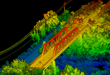
A new INS from Oxford Technical Solutions aims to break new ground in bringing high-quality navigation data to the Lidar surveying industry. Launched on 22 March 2021, the xNAV650 promises...
Modelling of urban areas, with emphasis on flat roof drainage calculations, is one application field in which the use of UAVs has significantly increased in recent years. A calibration base,...

Septentrio has opened a new Research & Development centre in Espoo, Finland, to support the strong growth and ambitious expansion plans for its GNSS/INS solutions for professional and industrial applications....

Established in 2001, Inertial Labs is a leader in position and orientation technologies for both commercial/industrial and aerospace/defense applications. With a worldwide distributor & representative network covering 20+ countries across...
SBG Systems is introducing the Virtual Base Station feature in its in-house post-processing software called Qinertia. Geospatial professionals benefit from an optimal centimetric position accuracy in all their projects, even...
PolyExplore has launched the Polyscanner LS1, a high-precision Lidar mapping system designed for UAVs and other aerial platforms. Based around advanced solid-state Lidar technology, the Polyscanner LS1 uses an innovative...

Trimble has introduced the Trimble R12i GNSS receiver, the latest addition to its Global Navigation Satellite System (GNSS) portfolio. The Trimble R12i incorporates Inertial Measurement Unit (IMU)-based tilt compensation using...

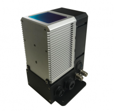
CHC Navigation (CHCNAV) has announced the release of the new CGI-610 GNSS/INS sensor, a high-precision dual-antenna receiver – designed to offer reliable and accurate navigation and positioning solutions for demanding...
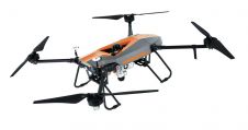
CHC Navigation (CHCNAV) has launched its new multi-rotor BB4 drone and AlphaUni 300/900/1300 Lidar. The groundbreaking combination of the AlphaUni 300/900/1300 Lidar and BB4 UAV solutions creates one of the...
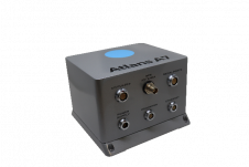
OGI has selected iXblue’s Atlans FOG-based inertial navigation system for its new mobile mapping Lidar solution dedicated to road assessment surveys. OGI, Oceanographic & Geophysical Instruments has selected iXblue’s Atlans...
This site uses cookies. By continuing to use this website, you agree to our Cookies Policy. Agree