Disaster Mapping 2.0
There has been a recent increase in the incidence of major disasters and the damage caused, in terms both of human suffering and economic cost. UNOSAT Mapping The main goal...
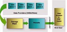
There has been a recent increase in the incidence of major disasters and the damage caused, in terms both of human suffering and economic cost. UNOSAT Mapping The main goal...
TatukGIS has released the 2.0 upgrade of its desktop GIS Editor product with new features such as advanced support for coordinate systems, many new data formats, and scripting for customising...
Satellite imagery provider DigitalGlobe (CO, USA) today released Citysphere 2.0, an enhanced version of its library of on-demand digital satellite imagery of the most populated global cities. CitySphere 2.0 features...
ScanEx R&D Center (Russia) has released version 2.0 of ScanMagic software, designed for Earth remote sensing data processing. The updated version supports popular cartographic services of Google, Microsoft and Yahoo....
Leica Geosystems (Swizerland) has released Leica MobileMatriX version 2.0; a multi-sensors GIS solution for capturing GIS data directly in the field. The new version 2.0 now supports Leica ATX1230 GG...
Leica SpiderWeb version 2.0 has been extended with additional features and services that improve the usability and efficiency for both service users and service providers. Leica SpiderWeb is easy to...
Version 2.0 of Leica GeoMoS has been released. This is a solution for multi-sensor structural monitoring using a range of high precision geodetic instruments from Leica Geosystems and third-party sensors....
DM Solutions Group (Canada) has made available Chameleon version 2.0, an Open Source software for creating customisable Web mapping applications. This latest version provides the flexibility to utilise both remote...
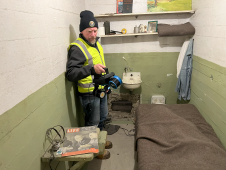
The rugged 22.5-acre site of the notorious US island prison Alcatraz has been digitally captured in a world-leading project involving multiple mapping technologies. With the team camped in the jail’s infamous cells for three weeks during the cold San Francisco winter, this historically, biologically and architecturally important location was recorded in unprecedented 3D detail. We discussed the project with project head Pete Kelsey and team member Dr Jeremy Sofonia. The rugged 22.5-acre site of the notorious US island prison Alcatraz has been digitally captured in a world-leading project involving multiple mapping technologies. With the team camped in the jail’s infamous cells...

Exyn Technologies has unveiled Exyn Nexys, an innovative modular 3D mapping solution. Designed for professionals in the mining, construction, AEC and geospatial industries, Nexys aims to set a new standard...
This site uses cookies. By continuing to use this website, you agree to our Cookies Policy. Agree