Dutch Land Registry Office Offers E-services
During a meeting in the Nieuwe Kerk (New Church) in The Hague on 25th October, Minister Dekker of the Ministry of Housing, Spatial Planning and the Environment (VROM) gave the...
During a meeting in the Nieuwe Kerk (New Church) in The Hague on 25th October, Minister Dekker of the Ministry of Housing, Spatial Planning and the Environment (VROM) gave the...
RMSI (CA, USA), a company in the geospatial information and software services industry, and its consortium partners have won a major data capture mapping contract, with Land Registry in Ireland....

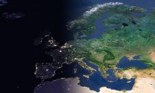
The Open Maps For Europe 2 (OME2) project has revealed plans to boost the utilization of European cadastral data. This includes efforts to enhance its discoverability and accessibility. As part...

Geo Connect Asia (GCA) is set to return to the Sands Expo and Convention Centre in Singapore on 6 March and 7 March 2024. Since its establishment in 2019, GCA...
EuroGeographics is drawing attention to the indispensable role of official national geospatial data in enhancing Copernicus Services, particularly within land monitoring and emergency management. This highlights a reinforced partnership between...

RIEGL has announced the launch of two innovative topobathymetric scanners. These advancements mark a shift towards enhanced efficiency and precision in data collection across land and water interfaces. The RIEGL...

Sven Cowan is NV5 Geospatial’s Programme Manager for Canada. He has over 20 years of experience in customer-facing positions within the geospatial information industry and has worked for multiple geospatial...

A topobathymetric Lidar survey was conducted to support flood preparedness in Canada. Which techniques achieved exceptional precision, and what were the logistical challenges? Find out more in this article. As...

Visitor registration is now open for GEO Business, the UK's largest geospatial event. The free-to-attend expo, tailored for geospatial professionals seeking to harness the potential of location intelligence, will return...

HM Land Registry (HMLR) and Registers of Scotland (RoS) are sharing their coveted INSPIRE spatial polygon datasets, which together map over 23 million title extents across England, Wales and Scotland,...
This site uses cookies. By continuing to use this website, you agree to our Cookies Policy. Agree