Cadastre in Wartime
Despite the current conflict, the topographic and cadastral land-register services of the Ukrainian StateGeoCadastre are still operational, certainly in the regions where the country is not under attack. Restricted public...

Despite the current conflict, the topographic and cadastral land-register services of the Ukrainian StateGeoCadastre are still operational, certainly in the regions where the country is not under attack. Restricted public...

Global reference systems such as the International Terrestrial Reference Frame provide the foundation for determining positions on Earth and in space, as well as for reliably quantifying our planet’s changes...
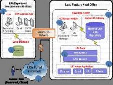
Libya has recently completed one of the biggest cadastre projects ever. A fully automated workflow has been established through all departments across the Land Registry Authority, supporting new working practices...
Through the collaborative implementation of satellite-derived bathymetry (SDB), the Danish Geodata Agency and EOMAP are synergizing efforts to contribute to the European Marine Observation and Data Network (EMODnet) Bathymetry partnership....

Over the past 20 years, various initiatives have been launched reflecting the importance of cadastral data for land management and spatial development. But how have these initiatives enhanced the possibility...
This site uses cookies. By continuing to use this website, you agree to our Cookies Policy. Agree