Cooperation for Geopdf State Coverage DVDs
The US Army Geospatial Center (AGC) and US Geological Survey (USGS) collaborated to create and disseminate a GeoPDF State Coverage DVD dataset recently. The GeoPDF State Coverage DVD dataset is...
The US Army Geospatial Center (AGC) and US Geological Survey (USGS) collaborated to create and disseminate a GeoPDF State Coverage DVD dataset recently. The GeoPDF State Coverage DVD dataset is...
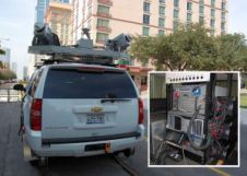
Surveying And Mapping, Inc. (SAM, Inc.) performed a mobile Lidar survey of the historic Sixth Street district in Austin, Texas, USA, for an urban planning project being conducting by the...
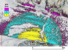
A team of scientists recently completed a research visit to Helheim Glacier in Southeast Greenland. The purpose of their research was to characterise the behaviour of the glacier using the...
In 2014, a joint publication by the World Bank and the International Federation of Surveyors (FIG) entitled 'Fit-for-Purpose Land Administration' noted that 75 percent of the world’s population do not...
In 2014, a joint publication by the World Bank and FIG noted that 75 percent of the world’s population do not have access to formal systems to register and safeguard...
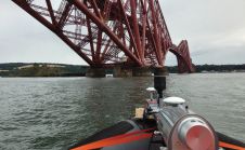
The iconic railway bridge and its companion road bridge have been scanned as part of a project to help inspire the next generation of Scottish engineers. Using a mobile mapping...
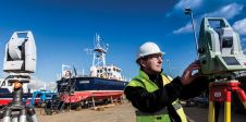
The world of hydrography is being opened up for new applications using a variety of boat-mounted sensors. Measurement of the relative positions of the sensors on board is vital for...
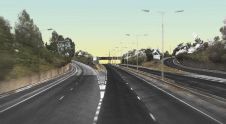
Jacobs Geomatics provides support and consultancy to the company’s wider design and engineering services. In recent years Jacobs’ UK geomatics team has been involved in increasingly large infrastructure schemes, typically...

Aligned Assets have announced the publication of two case studies that focus on the use of accurate addressing data at the centre of integrated, operational systems within the UK Police....
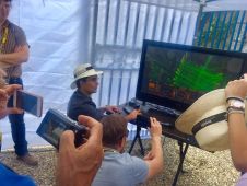
'GIM International' took the opportunity to ask Tristan Allouis, chief technical officer and one of the co-founders of YellowScan, a few questions on the French company’s area of specialisation: Lidar mapping...
This site uses cookies. By continuing to use this website, you agree to our Cookies Policy. Agree