Monitoring Coastal Erosion with UAV Lidar
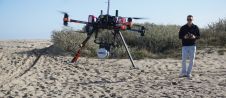
This survey in southern France confirmed the suitability of UAV Lidar for mapping shoreline changes in the context of erosion and drinking water availability. The French Mediterranean coast is a...
This survey in southern France confirmed the suitability of UAV Lidar for mapping shoreline changes in the context of erosion and drinking water availability. The French Mediterranean coast is a...
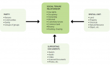
High-end technology-driven solutions often create serious implementation constraints in land administration. Furthermore, despite the developments and advances in geo-ICT, there is still a gap in the development of tools that...
Optech, Canada, has developed a lightweight mounting platform for its Lynx Mobile Mapper. The rack features rigid mounting points and latching that virtually eliminate any slippage or vibration, ensuring consistent...
This site uses cookies. By continuing to use this website, you agree to our Cookies Policy. Agree