Multi-sensor Coastal Mapping
Fugro has tested a multi-sensor approach to balance growing data needs with limited agency budgets. Coastal mapping programmes are quickly becoming a priority for government agencies across the globe. The desire...
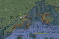
Fugro has tested a multi-sensor approach to balance growing data needs with limited agency budgets. Coastal mapping programmes are quickly becoming a priority for government agencies across the globe. The desire...
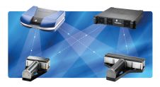
Applanix has introduced POSPac MMS 8 GNSS-aided inertial post-processing software for georeferencing data collected from cameras, Lidars, multibeam sonar and other sensors on mobile platforms. The announcement was made on...
Teledyne RESON has introduced four new multibeam sonar systems: the Integrated Dual Head SeaBat T20-R & T50-R and the modular SeaBat T20-R & T50-R Multibeam Sonar. These new multibeam sonar are all...
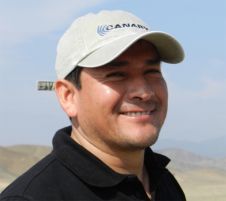
Seafloor Systems has announced the appointment of Mauro Romani as sales support engineer for the Latin American market. Mr Romani, who previously served as a geotechnical equipment specialist for Golder Associates...
Knowing the volume of material present in a gravel quarry can make the difference between profit and loss. A gravel quarry in Hartheim am Rhein, southwest Germany, is partially covered...

Proposals to privatise the Land Registry take centre stage whilst we also examine the latest inshore hydrographic technology, the Internet of Things, BIM and someone thinks ‘the times they are...

Engineering technologies company Renishaw has teamed up with hydrographic equipment provider Cadden to supply their vessel-based lidar scanner, Merlin, to the marine surveying industry. Cadden is a proven specialist provider...

Geo-matching.com has recently added rental companies and dealers to its overview of products and solutions. Besides detailed information about the manufacturers of products and brands, Geo-matching.com users can now also...

These are exciting times in the geomatics industry. Innovative solutions are being developed, integration is the main keyword and the big players are acquiring smaller companies that add a new...

Trimble Applanix designs, builds, delivers and supports products and solutions designed specifically for the hydrographic survey industry. Our products and solutions provide robust, reliable and repeatable positioning and motion compensation...
This site uses cookies. By continuing to use this website, you agree to our Cookies Policy. Agree