Dual GPS
OxTS is releasing a new dual antenna version of the Inertial+ navigation system at this year's Intergeo exhibition. The new Inertial+2 provides improved heading accuracy for better performances in airborne...
OxTS is releasing a new dual antenna version of the Inertial+ navigation system at this year's Intergeo exhibition. The new Inertial+2 provides improved heading accuracy for better performances in airborne...
We are a company that provides digital cartography solutions designed to meet our clients’ needs and obtain levels of precision that guarantee their trust in us. To achieve this, we...
Teledyne DALSA will showcase its latest cameras and machine vision solutions at VISION 2012 in Stuttgart, Germany from 6 to 8 November, 2012. Teledyne DALSA’s full range of line and...

Leica Geosystems and Kadaster, the Dutch Land Registry, have signed an agreement for the supply of land surveying data collection equipment for the coming five years. For Leica Geosystems, this...
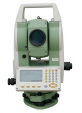
FOIF announces a new, unique reflectorless EDM R1000, a long distance measurement 1000 meters (Condition: Sunny, Light haze, visibility about 20 km; slight heat shimmer). In addition to having the...
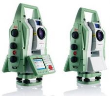
Leica Geosystems has announced the Leica Nova TS50 high-precision total station and Nova TM50 monitoring station for applications that require uncompromising precision and reliability. The total station and monitoring station...

OxTS, UK, has launched the GPS-aided inertial navigation system xNAV200 at this year's AUVSI Unmanned Systems North America conference in Las Vegas, USA. The xNAV200 is a compact, lightweight INS....

NASA has purchased 22 Leica Viva TS15 robotic total stations from Leica Geosystems. The total stations will be used to monitor critical displacements on the Space Launch System (SLS) test...

A pioneering, mechanised system for track construction, developed by Alstom Transport and Leica Geosystems, is driving the speedy, high accuracy delivery of two new tramlines for Nottingham Express Transit (NET)....

A pioneering, mechanised system for track construction, developed by Alstom Transport and Leica Geosystems, is driving the speedy, high-accuracy delivery of two new tram lines for Nottingham Express Transit (NET)....
This site uses cookies. By continuing to use this website, you agree to our Cookies Policy. Agree