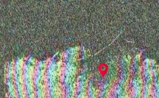
SAR Images of Beirut Explosion
On Tuesday 4 August, at approximately 18:00 local time, a terrible accident occurred in the main port in Beirut, Lebanon. A large explosion caused by a stockpile of over 2,700...
On Tuesday 4 August, at approximately 18:00 local time, a terrible accident occurred in the main port in Beirut, Lebanon. A large explosion caused by a stockpile of over 2,700...
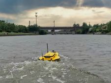
This paper explores the various features of the Apache USV series for efficient seafloor-level mapping. The CHCNAV hydrographic survey software is used for data recording and analysis. It provides results...

CHC Navigation (CHCNAV) has announced the release of the new CGI-610 GNSS/INS sensor, a high-precision dual-antenna receiver – designed to offer reliable and accurate navigation and positioning solutions for demanding...
From New York to Dubai to Myanmar, more smart cities are springing up across the globe. As more countries start to digitally transform, the futuristic cities and state-of-the-art gadgets that once...
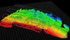
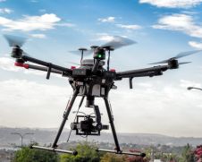
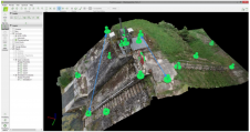
Unmanned Aerial Vehicle (UAV) Lidar offers unparalleled capability where accurate mapping is essential but difficult to achieve. In particular, hard to reach, hazardous environments where access is dangerous. Areas where...
Despite a maturing infrastructure investment market, private capital sufficient to support US$1trn of infrastructure development is currently going unspent, according to a report commissioned by RICS’ World Built Environment Forum:...

It is Thursday 14 May 2020, and today should have been the closing day of FIG Working Week in Amsterdam. The programme of today would have been the second General...
The skills that engineering surveyors had to acquire in order to respond to the challenges of the construction world have made them capable, also, of fulfilling other challenges, several of...
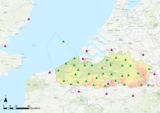
A continuously operating reference station (CORS) provides GNSS data to support very accurate 3D positioning and additional geophysical applications. Flemish Positioning Services (FLEPOS) is the real-time global navigation satellite system...
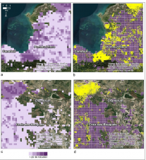
In a project in Haiti, several remotely sensed indicators were assessed to predict the completeness of Open Street Map for use in disaster relief and to guide future mapping efforts....
This site uses cookies. By continuing to use this website, you agree to our Cookies Policy. Agree