Geospatial Sciences at UCL
We must occasionally look like Monty Python’s Judean People’s Front, carefully honing their differences with the Peoples’ Front for Judea. We are Geomatic Engineers, interested in Geospatial Sciences. How many...

We must occasionally look like Monty Python’s Judean People’s Front, carefully honing their differences with the Peoples’ Front for Judea. We are Geomatic Engineers, interested in Geospatial Sciences. How many...

SimActive is a leading developer of photogrammetry software. The Canadian company, which was founded by two brothers – Louis and Philippe Simard – in 2003, celebrates its 15th anniversary this...
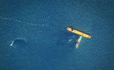
French and Italian maritime authorities have commenced cleaning a major spill that has spread 20km in the Mediterranean Sea after two cargo ships collided north of Corsica on Monday 8 October 2018....
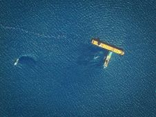
French and Italian maritime authorities have commenced cleanup of a major oil spill that has spread 20 kilometres in the Mediterranean Sea after two cargo ships collided north of the island...

Esri has announced that Argentina's coast guard, Prefectura Naval, and Aeroterra S.A. have partnered to implement Esri's ArcGIS platform for a real-time tracking system. The new system, called Guardacostas Pro,...
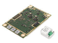
GNSS receiver manufacturer Septentrio has announced the addition of the AsteRx-i S to its GNSS/INS product portfolio. The AsteRx-i S combines Septentrio’s compact, multi-frequency multi-constellation GNSS engine with ultralight external...
Mining technology developer Maptek and augmented reality experts LlamaZOO are teaming up together to bring digital twinning and advanced 3D data visualisation to the mining industry. LlamaZOO Interactive is an...

Airobotics, the Israeli startup that built the world’s first fully automated drone, has announced it is partnering with Shapir-Ashtrom. The two companies will be working together to survey the construction...

GIS Professionals within large corporate organisations sometimes find themselves at odds with ‘general IT’ management. Some CIOs, IT Managers or Enterprise Architects lack a full understanding of GIS and, as...

Based on a future-oriented, innovative new processing architecture, internet connectivity and RIEGL‘s latest waveform processing Lidar technology, the RIEGL VZ-2000i Long Range 3D Laser Scanner System combines proven user friendliness in the field...
This site uses cookies. By continuing to use this website, you agree to our Cookies Policy. Agree