Trimble VX Spatial Station
Trimble (CA, USA) has introduced the Trimble VX Spatial Station, apositioning system that combines optical, 3D scanning and video capabilities - Trimble VISION technology - to measure objects in 3D...
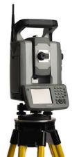
Trimble (CA, USA) has introduced the Trimble VX Spatial Station, apositioning system that combines optical, 3D scanning and video capabilities - Trimble VISION technology - to measure objects in 3D...
Thales’ navigation business (CA, USA) has formed another partnership in its Business Partner Program aimed at providing MobileMapper CE customers with a broad choice of software applications to suit their...
National Geographic (DC, USA) has released a new tool to add topographic maps to their projects with National Geographic Maps' TOPO! Xport Pro. This software enables users to add seamless...
Trimble (CA, USA) has introduced the Trimble 5800 Limited GPS System for the North American market. The system combines a dual-frequency GPS receiver, antenna, UHF radio, and battery in a...
Leica Geosystems Geospatial Imaging (GA, USA) has announced it will partner with Visual Learning Systems, Inc. (VLS) (MT, USA) to resell VLS Feature Analyst and LIDAR Analyst as add-on programs...
ISPRS is a truly international Society, representing more than one hundred countries and regions around the world. However, many ISPRS member countries have inadequate finances to enable them to carry...
Bentley Systems, Incorporated has opened the registration for BE Conference 2007, being held 29th April 29- 3rd May at the Los Angeles Convention Center in California, USA. Those registering by...
Current National Spatial Data Infrastructure (SDI) activities clearly demonstrate the many ways in which SDIs reflect local political, institutional and cultural factors. In Great Britain, the Northern Ireland plan is...
Current National Spatial Data Infrastructure (SDI) activities clearly demonstrate the many ways in which SDIs reflect local political, institutional and cultural factors. In Great Britain, the Northern Ireland plan is...
Overwatch Systems (VA, USA) has deployed more than 12,000 seat licenses for its RemoteView-Pro imagery visualisation and geospatial analysis software system. RemoteView, developed by Sensor Systems which changed its name...
This site uses cookies. By continuing to use this website, you agree to our Cookies Policy. Agree