3D Modelling for Construction
When it comes to 3D modelling for construction, what are the advantages and disadvantages of photogrammetry versus Lidar in terms of accuracy, complexity and cost? Breaking away from laser measurement...
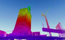
When it comes to 3D modelling for construction, what are the advantages and disadvantages of photogrammetry versus Lidar in terms of accuracy, complexity and cost? Breaking away from laser measurement...

Eos Positioning Systems (Eos), the Canadian manufacturer of the high-accuracy Arrow Series GNSS receivers, has announced the compatibility of its Eos Locate for ArcGIS underground-mapping solution with three Subsite Electronics products....

Working with Pittsburgh’s City Planning Department, a Carnegie Mellon University research team completed an in-depth study of the current use of 3D software for planning tasks and public communication.[1] The team...

A unique 3D smart digital model has been developed to combine the different streams of data from cities on one common platform, and is the result of the ITEA project PS-CRIMSON, a...

Trimble has introduced the Trimble R12i GNSS receiver, the latest addition to its Global Navigation Satellite System (GNSS) portfolio. The Trimble R12i incorporates Inertial Measurement Unit (IMU)-based tilt compensation using...

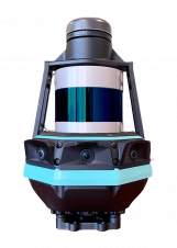
Geomaat recently performed extensive 3D laser scanning and 3D modelling for the Dutch railway organization, ProRail. ProRail is the organization that takes care of the entire railway network in the Netherlands,...

An approach for valuing rural customary farmlands has been assessed in a case study in Ghana with a view to supporting land consolidation for food security. Customary lands account for 80% of...

Kaarta, the innovator of real-time mobile 3D reality capture, has announced Kaarta Cloud, a new solution to process, store and share 3D spaces. It provides a fast, convenient and flexible...
Kaarta, a specialist in real-time mobile 3D reality capture, is introducing Stencil Pro, a professional-grade mobile mapping platform with high-quality dimensional and visual fidelity. The multipurpose Stencil Pro mobile mapping...

Spatial analysis by Esri UK has found that most pavements around the country are less than 3 metres wide, making it difficult for pedestrians to remain 2 metres apart and follow government...
This site uses cookies. By continuing to use this website, you agree to our Cookies Policy. Agree