Linking Geospatial Database with GIS
The database vendor Oracle Corporation has for a long time shown a strong interest in geospatial data storage. For a fuller picture of the spatial aspects of their latest product,...
The database vendor Oracle Corporation has for a long time shown a strong interest in geospatial data storage. For a fuller picture of the spatial aspects of their latest product,...
The database vendor Oracle Corporation has for a long time shown a strong interest in geospatial data storage. For a fuller picture of the spatial aspects of their latest product,...
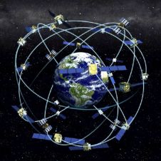
Receiver position is calculated from the position of satellites and the distances to them. Distance is calculated from the time a radio signal travels between satellite and receiver. But how...
Cardinal Systems, LLC (FL, USA) has announced that it’s Vr Mapping Software has been selected by NASA for use in quantifying potential tile and wing leading edge damage on upcoming...
INPHO (Germany) has announced launching of a new version of its fully automatic DTM generation software, MATCH-T 4.0. The major changes and improvements compared to the previous versions are: processing...
Leica Geosystems GIS & Mapping, LLC (GA, USA) has announced the release of Leica Photogrammetry Suite (LPS) V8.7 Service Pack 2 (SP2) - ADS40 Update. The update provides users the...
Anomalies such as building-lean result from the processing of traditional orthorectified imagery and this limits its use in urban areas. However, the arrival of digital sensors has meant fully orthorectified...
Sport England manages distribution amongst sporting organisations of UK government and lottery funds. It is committed to creating opportunities for people to take up, continue participating in and succeed in...
LiDAR Services International (LSI) (Canada) has recently purchased the new Riegl model Q-560 laser scanner which incorporates full waveform digitising of all return laser pulses. With this purchase, LSI becomes...
Airborne 1 Corporation (CA, USA) has announced the company’s third annual TerraScan User Event. This informative week-long training session for both beginners and intermediate users of Terrasolid products will be...
This site uses cookies. By continuing to use this website, you agree to our Cookies Policy. Agree