Surveying the Past Using a Drone
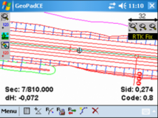
Due to the dense tree cover, Lidar was used in a drone survey of the Caesar’s Camp site, an ‘oppidum’ (fortified habitat) in France dating from around 100 BC. Archaeology...
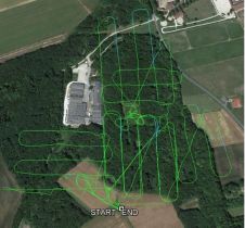
Due to the dense tree cover, Lidar was used in a drone survey of the Caesar’s Camp site, an ‘oppidum’ (fortified habitat) in France dating from around 100 BC. Archaeology...
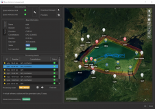
Which technologies and processes are building the capability for high-density 3D data? Point clouds can be captured by an ever-increasing number of means to understand the surrounding reality and detect critical...

SBG Systems will present for the first time at AUVSI’s Xponential show in Chicago, USA, the Quanta UAV Series, a new line of inertial navigation systems (INS) dedicated to UAV-based...
SBG Systems’ popular INS/GNSS PPK software called Qinertia now covers all surveyors’ projects by offering a licence dedicated to GNSS post-processing, according to the France-based company. Open to the world,...

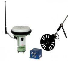
During the International LiDAR Mapping Forum in Denver, USA, SBG Systems released the Horizon IMU, a FOG-based high-performance inertial measurement unit (IMU) designed for highly demanding surveying applications including high-altitude...
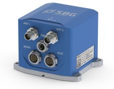
SBG Systems has announced the Ekinox 2 Series, a next generation of the advanced and compact inertial navigation systems. With accelerometers and gyroscopes, Ekinox 2 attitude accuracy has been enhanced...

SBG Systems has released the FOG-based Horizon inertial measurement unit (IMU), designed for high demanding surveying applications such as high-altitude data collection, or mobile mapping in very dense areas such...
SBG Systems is introducing the Virtual Base Station feature in its in-house post-processing software called Qinertia. Geospatial professionals benefit from an optimal centimetric position accuracy in all their projects, even...
SBG (Sweden) has released Stringline model software which produces a complete 3D model representing any type of road. It is an all new reference type that uses parallel stringlines. The...
SBG Systems has introduced Ekinox Land Solution, an all-in-one solution combining the cost-effective Inertial Navigation System with an odometer, and a GNSS RTK reference station for smooth positioning in land...
This site uses cookies. By continuing to use this website, you agree to our Cookies Policy. Agree