UK Storm Surge Impacts Mapped Using UAS
One year on from the biggest UK storm surge for 60 years, new aerial photos have revealed details of breaches to the natural and manmade coastal defences on part of...
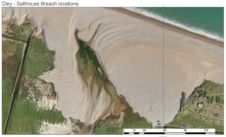
One year on from the biggest UK storm surge for 60 years, new aerial photos have revealed details of breaches to the natural and manmade coastal defences on part of...

Although experts are making a considerable effort to provide a clear definition of high-nature value farmland (HNVF), its complex nature prevents the establishment of a straightforward approach to inventory and...

Google is buying Skybox Imaging for USD500 million. The internet company hopes the deal will lead to improvements in the quality and immediacy of the satellite imagery used in its...

In Addis Ababa, Ethiopia, the United Nations Economic Commission for Africa has a Geoinformation Support Team of a dozen people striving to develop spatial data infrastructures (SDIs) Africa-wide. “Progress on...

Thursday 2 April saw the launch of the Sentinel-1A, the first dedicated satellite in the European Earth observation programme Copernicus. The data it emits from space will open doors to...
Thanks to the accurate management of the camera resolution and the control of speed, direction and position, the Aibot X6 captures a cartographic area through reinterpretation of conventional photogrammetry. The...

This year, Intergeo is being held just a stone’s throw away from the Essen Mühlheim Airport in Germany. Airborne Technologies plans to use this opportunity to bring one of its...

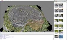
Having signed a five-year sponsorship with BYU University of Utah, USA, Pix4uav has recently been used to create the first ever detailed map of the Ad Deir Plateau in Petra,...
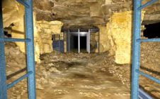
Laser scanning technology has been used to create a permanent and lasting record of post-mediaeval underground mines under the city of Bath, UK. The project by Oxford Archaeology employed laser...
The full feature is online at http://member.gim-international.com/. Please subscribe for free using the Subscribe button in the left hand column. Archaeologists nowadays have a broad range of geomatics tools and...
This site uses cookies. By continuing to use this website, you agree to our Cookies Policy. Agree