WWII USS Lexington Discovered off Queensland Coast
The wreck of the USS Lexington, a historic WWII U.S. aircraft carrier that was scuttled during the Battle of the Coral Sea, has been discovered around 800 kilometres from Queensland’s...
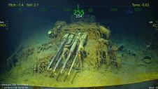
The wreck of the USS Lexington, a historic WWII U.S. aircraft carrier that was scuttled during the Battle of the Coral Sea, has been discovered around 800 kilometres from Queensland’s...
Phil Payne gives a personal account of his experience in the Caribbean at the time of Hurricane Irma. He reminisces on the usefulness of basic techniques when the latest systems...

The Virtual Geoscience Conference (VGC) series is coming to Kingston, Canada, from 23-24 August 2018. The focus of the conference series is on innovative research and development in close-range remote...
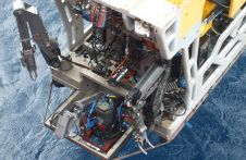
A new chapter in the search for Malaysia Airlines flight MH370 has begun with the announcement of Texas-based firm Ocean Infinity being hired to locate the missing wreckage. They could...

Gottfried Mandlburger studied geodesy at TU Wien, where he also obtained his Ph.D. in 2006. After finishing a 3-years research stay at the University of Stuttgart (2017-2019), he returned to...
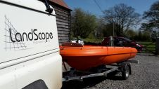
LandScope has recently integrated an R2Sonic 2020 multibeam echo-sounder to its arsenal in order to complement our established underwater structure modelling and bathymetric survey capabilities. Offering a 120-degree swath, the...
Subsea technology companies, 2G Robotics Inc., and Sonardyne International Ltd, UK. Has announced they have entered into a formal collaboration agreement. The two organisations are working together on the development...
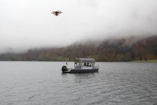
What is the best way to generate a high-precision 3D model to estimate the storage capacity of a lake that is surrounded by mountains? Rapid weather changes, low clouds and...

Great advancements have been made in three dimensional printing over the last few years and have made an impressionable impact across a variety of industries. 3D printing's versatility can be...
Fugro has tested a multi-sensor approach to balance growing data needs with limited agency budgets. Coastal mapping programmes are quickly becoming a priority for government agencies across the globe. The desire...
This site uses cookies. By continuing to use this website, you agree to our Cookies Policy. Agree