Developing the digital sub-surface model for Crossrail 2
A 3D geological model has helped to save valuable time and millions of pounds for the Crossrail 2 railway project in London, UK, by identifying geological hazards along the route...
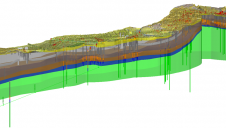
A 3D geological model has helped to save valuable time and millions of pounds for the Crossrail 2 railway project in London, UK, by identifying geological hazards along the route...
Fajar N Adi is head of the Sub Directorate of System Development of Land Services at MoASP/BPN.
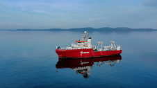
Fugro has completed the offshore fieldwork phase of a high-profile multidisciplinary contract for Global Marine that will help determine subsea routes for 16 new fibre-optic cables in the Scottish archipelago...
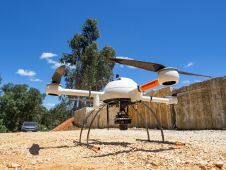
The mission: capturing 21 quarries in 60 days. Squeezed into that timeframe were planning and performing the UAV photogrammetry flights, editing the RAW images, processing the data, extracting the topography using Virtual Surveyor, and production of the orthophotos, Digital Surface Model (DSM), Digital Terrain Model (DTM) and contour maps for each site. The main client, a government institute, needed highly precise and reliable 3D models and maps fast, as well as data their engineers could work with in a CAD environment. “There was a lot of pressure because of the short timeline”, said Nuno Santos, owner and CEO of Aerisurvey, a Mangualde, Portugal-based company specialized in high-precision UAV surveying. Mapping 21 Quarries in 60 Days The mission was to capture 21 quarries in 60 days. Squeezed into that timeframe were planning and performing the UAV photogrammetry flights, editing the...

OxTS has grown rapidly over the last few years and we are looking for distributors to join our network. At OxTS, we have dedicated ourselves to developing industry-leading GNSS-aided inertial navigation technology. Since 1998, our products have been used and trusted world-wide for all applications where reliable, continuous position information as well as highly precise orientation data matter. Our successful business model has always been our inhouse expertise combined with that of our valued channel partners/distributors. Succeed With Confidence As Part of OxTS' Global Network OxTS has grown rapidly over the last few years and we are looking for distributors to join our network. At OxTS,...
Bathymetric Lidar is a technique that is used to capture geospatial data of coastlines and waterbodies. The method has the potential to facilitate the fast and efficient creation of hydrographic data, and more...

As the demand for elevation data continues to rise, it is important that users match the level of reliability, accuracy and resolution of the data to their specific application to...

A two-part webinar series entitled ‘Mapping the Seafloor around Africa’ was jointly organized by the IOC-UNESCO Sub-Commission for Africa and the Adjacent Island States (IOCAFRICA) and the Nippon Foundation-GEBCO Seabed...
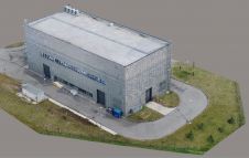
Modelling of urban areas, with emphasis on flat roof drainage calculations, is one application field in which the use of UAVs has significantly increased in recent years. A calibration base,...
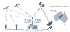
Australia and New Zealand’s operational Satellite Based Augmentation System (SBAS) has officially been named the Southern Positioning Augmentation Network, or SouthPAN. SouthPAN will be the first SBAS in the Southern...
This site uses cookies. By continuing to use this website, you agree to our Cookies Policy. Agree