The Expanding Use of UAVs in Construction
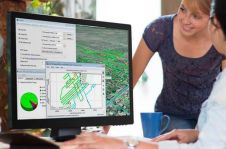
It is an exciting time for geospatial professionals. The data that can now be obtained using unmanned aerial vehicles (UAVs, or drones) opens up previously impossible opportunities in many different...
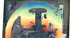
It is an exciting time for geospatial professionals. The data that can now be obtained using unmanned aerial vehicles (UAVs, or drones) opens up previously impossible opportunities in many different...

Mark Heine is chairman of the board and CEO of Fugro, with the headquarters in the Netherlands. Fugro is the leading and largest specialised survey company in the world, serving the full lifecycle of assets, and calls itself a Geo-data specialist. For the avid mountaineer Heine, challenges are never too high to take on, not even heading up a multinational in transition, from a company largely dependent on the oil and gas industry to one that wants to co-create a sustainable and liveable world. We talked to Mark Heine about leadership style, strategies for finding new employees, and Seabed 2030. About this ambitious project, Heine says ‘Commercial companies need to work together with NGOs and academia to make this happen.’ Mark Heine is chairman of the board and CEO of Fugro, which is headquartered in the Netherlands. Fugro is among the leading and largest specialized survey companies in the world,...

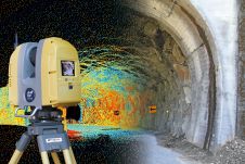
Highly accurate, UK citywide 3D models are now available to view and download from Bluesky’s online Mapshop. The geographically accurate, photo-realistic MetroVista mesh models are available in a variety of...
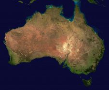
The Australasian region took a major step towards gaining its first-ever satellite-based augmentation system (SBAS) in early 2017. That is when the governments of Australia and New Zealand agreed to...

As France’s top rugby players scrum, run and tackle they are being tracked by more than just TV cameras and the watching eyes of the crowd. Satnav-based tracking devices between...
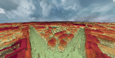
A dense annotated ground-truth Lidar dataset of the city of Dublin is the first of its kind regarding the accuracy, density and diversity of classes. The hierarchical labels offer excellent...

China has recently shared the first high-resolution 3D images captured by the Gaofen-7 imaging satellite, which was launched in November. The satellite – the latest in a series of 14...
It is estimated that the global construction industry will grow to US$10.3 trillion by 2020. Arguably, the development and investment in ever-more innovative digital tools will be key in enabling that...
Septentrio, a leading manufacturer of accurate and reliable GPS technology, has released a key upgrade for their GPS post-processing software. Both GeoTagZ and PP-SDK now feature BaseFinder, a tool that speeds up survey workflow...

Geospatial intelligence can play a fundamental role in communicating the economic cost of climate change in the 21st century. With more availability of spatial resolution, the environmental effects of global...
This site uses cookies. By continuing to use this website, you agree to our Cookies Policy. Agree