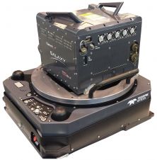
Optech Galaxy T1000 Built for Savings
Teledyne Optech has announced a new entry in its in Galaxy ALTM line of airborne scanners. The Galaxy T1000 offers a 1000 kHz effective ground measurement rate, effectively doubling the...

Teledyne Optech has announced a new entry in its in Galaxy ALTM line of airborne scanners. The Galaxy T1000 offers a 1000 kHz effective ground measurement rate, effectively doubling the...

Andy Hoggarth is vice president of sales and marketing at Teledyne Geospatial.

Teledyne Optech has revealed that Huron Geomatics Inc (HGI), who provides DSM/DTM modelling, mapping, and asset inventory collection services, has acquired an Optech Maverick mobile mapping system that will support...

Ocean Business returned to Southampton between 4-6 April and Joost Boers was there for readers. This year’s Ocean Business marked the tenth anniversary of the event - and there was...

A laser scanner was deployed when a tunnel roof collapsed at a hydroelectric dam construction site in Bhutan. Surveying cavities in underground excavation projects can be difficult and dangerous. The collapse...

With the launch of Sentinel-3B, the seventh satellite in the Copernicus programme which monitors the Earth’s environment, the UK space sector has secured contracts worth more than €12 million on...
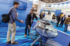
London’s docklands became home to a fleet of both manned and unmanned surface and subsea vehicles during this year’s Oceanology International 2018 (Oi18), reflecting an increasing focus on connected autonomous...
Teledyne Optech has announced Asia Air Survey Co. (AAS), Tokyo, Japan, has taken delivery of an ALTM Galaxy T1000 for use in their forest resource management initiatives, road and railway...
According to a comprehensive new market research report, the overall Lidar market is expected to reach over US$1.8 billion by 2023, up from US$819.1 million in 2018, at a CAGR...
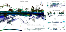
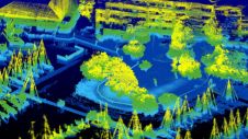
Mobile Lidar systems (MLSs) are used with increasing frequency for three-dimensional (3D) mapping applications along various corridors because of their extreme ease in capturing high-resolution 3D topographic data. This article...
This site uses cookies. By continuing to use this website, you agree to our Cookies Policy. Agree